IMAGES TAKEN NEAR TO
Rheidol Avenue, SWANSEA, SA6 7JY
Introduction
This page details the photographs taken nearby to Rheidol Avenue, SA6 7JY by members of the Geograph project.
The Geograph project started in 2005 with the aim of publishing, organising and preserving representative images for every square kilometre of Great Britain, Ireland and the Isle of Man.

There are currently over 7.5m images from over14,400 individuals and you can help contribute to the project by visiting https://www.geograph.org.uk
Image Map
Images are licensed for reuse under creativecommons.org/licenses/by-sa/2.0
Notes
- Clicking on the map will re-center to the selected point.
- The higher the marker number, the further away the image location is from the centre of the postcode.
Image Listing (8 Images Found)
Images are licensed for reuse under creativecommons.org/licenses/by-sa/2.0
Image
Details
Distance
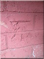
1
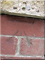
Ordnance Survey Cut Mark
This OS cut mark can be found on No153 Solva Road. It marks a point 147.554m. above mean sea level.
Image: © Adrian Dust
Taken: 16 Jul 2014
0.05 miles
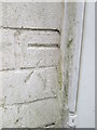
2
Ordnance Survey Cut Mark
This OS cut mark can be found on the SW face of Clase Primary School. It marks a point 162.529m. above mean sea level.
Image: © Adrian Dust
Taken: 16 Jul 2014
0.12 miles
3
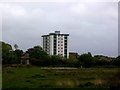
Clase
Tower block at Clase, near Morriston, Swansea. Seen from the western edge of the grid square, looking across Mynydd-bach common.
Image: © Kevin Flynn
Taken: 18 May 2006
0.12 miles
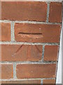
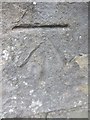
4
Ordnance Survey Cut Mark
This OS cut mark can be found on No64 Solva Road. It marks a point 144.164m above mean sea level.
Image: © Adrian Dust
Taken: 16 Jul 2014
0.17 miles
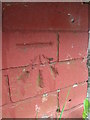
5
Ordnance Survey Cut Mark
This OS cut mark can be found on No91 Solva Road. It marks a point 134.213m. above mean sea level.
Image: © Adrian Dust
Taken: 16 Jul 2014
0.19 miles
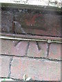
6
Ordnance Survey Cut Mark
This OS cut mark can be found on the north face of the Old Police Station building on Long View Road. Now housing. It marks a point 156.426m above mean sea level.
Image: © Adrian Dust
Taken: 16 Jul 2014
0.21 miles
7
Ordnance Survey Cut Mark
This OS cut mark can be found on the stone post at the junction of Tirdeunaw Close & Llangyfelach Road. It marks a point 145.213m above mean sea level.
Image: © Adrian Dust
Taken: 29 Jan 2014
0.24 miles
8
Ordnance Survey Cut Mark
This OS cut mark can be found on No29 Long View Road. It marks a point 149.672m above mean sea level.
Image: © Adrian Dust
Taken: 16 Jul 2014
0.24 miles