IMAGES TAKEN NEAR TO
Llanddewi Velfrey, NARBERTH, SA67 8UT
Introduction
This page details the photographs taken nearby to SA67 8UT by members of the Geograph project.
The Geograph project started in 2005 with the aim of publishing, organising and preserving representative images for every square kilometre of Great Britain, Ireland and the Isle of Man.

There are currently over 7.5m images from over14,400 individuals and you can help contribute to the project by visiting https://www.geograph.org.uk
Image Map (Loading...)


Getting Data...Please wait
Leaflet Map data © OpenStreetMap
Images are licensed for reuse under creativecommons.org/licenses/by-sa/2.0
Notes
- Clicking on the map will re-center to the selected point.
- The higher the marker number, the further away the image location is from the centre of the postcode.
Image Listing (12 Images Found)
Images are licensed for reuse under creativecommons.org/licenses/by-sa/2.0
Image
Details
Distance
1
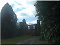
Plas Crwn ruin in Llanddewi Velfrey Parish
Having taken the wrong path I drove through manicured grounds that could have passed for being ecclesiastical and rounded the bend to see these ruins, Plas Crwn, once a manor house. The lane continued beyond to open out into a spectacular courtyard where there were horses, cats and dogs, and inhabited.
On return, I had to find out a bit more about this lovely place. The George family lived there in the C19th and Fanny Margaret George married Thomas Reece Thomas of Llanboidy c1796-1883. He was connected to the Willy family of Lampeter Velfrey and a surgeon of Haverfordwest. Their son was Tudor Vaughan Howell Thomas 1852-1906.
The 1907 OS map for Carmarthenshire XXXVI Sheet 16 lists an arboretum; woodland; shrubbery; lodge; gatehouse; haw haw; house; conservatory; walled garden; carriage drive and parkland http://www.coflein.gov.uk/en/site/86569/details/plas-crwnplas-crwm-garden-llanddewi-velfry
I don't know when Plas Crwn fell into ruin.
Image: © Deborah Tilley
Taken: 22 Feb 2009
0.01 miles
2
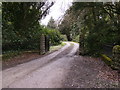
Entrance to Plas Crwn
Very grand well used entrance to a...... ruin! See Image by Deborah Tilley, further down the lane out of picture to the right, is another entrance, that shows plenty of habitation, I think the old outhouses of the "ruin" have been converted into dwellings.
Image: © chris whitehouse
Taken: 24 Apr 2012
0.11 miles
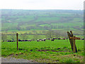
3
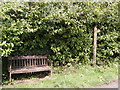
Bench opposite entrance to Cwmllefrith
Lovely setting for a bench, photoImage shows the view to admire.
Image: © chris whitehouse
Taken: 24 Apr 2012
0.14 miles
4
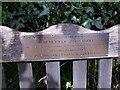
Plaque on bench
A welcome bench on this lane if anyone is walking to St. David's Church, opposite entrance to Cwmllefrith.
Image: © chris whitehouse
Taken: 24 Apr 2012
0.15 miles
5
Cwmllefrith entrance sign
Looking for St. David's Church! but this is as far as I managed, will try again from a different direction.
Image: © chris whitehouse
Taken: 24 Apr 2012
0.16 miles
6
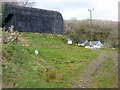
Plas-Crwn Farm Building
The re-routed footpath goes down some steps on the left of picture and onto the track. The map marked track is on the other side of the black barn and leads into the main farm area.
Image: © R Simpson
Taken: 16 Apr 2009
0.16 miles
7
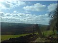
At the lane junction to Cwmllefrith looking south west
Looking out over verdant pasture. There are a number of Iron Age hillforts in the vicinity.
Image: © Deborah Tilley
Taken: 22 Feb 2009
0.18 miles
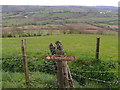
9
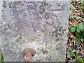
Ordnance Survey Cut Mark
This OS cut mark can be found on the gatepost east side of the entrance. It marks a point 119.975m above mean sea level.
Image: © Adrian Dust
Taken: 15 Jan 2017
0.21 miles
10
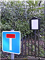
Entrance to St. David's Church
And a no through road!!! a very long footpath.
Image: © chris whitehouse
Taken: 24 Apr 2012
0.21 miles