Plas Crwn ruin in Llanddewi Velfrey Parish
Introduction
The photograph on this page of Plas Crwn ruin in Llanddewi Velfrey Parish by Deborah Tilley as part of the Geograph project.
The Geograph project started in 2005 with the aim of publishing, organising and preserving representative images for every square kilometre of Great Britain, Ireland and the Isle of Man.

There are currently over 7.5m images from over 14,400 individuals and you can help contribute to the project by visiting https://www.geograph.org.uk
Plas Crwn ruin in Llanddewi Velfrey Parish
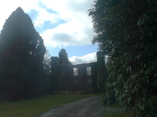
Image: © Deborah Tilley Taken: 22 Feb 2009
Having taken the wrong path I drove through manicured grounds that could have passed for being ecclesiastical and rounded the bend to see these ruins, Plas Crwn, once a manor house. The lane continued beyond to open out into a spectacular courtyard where there were horses, cats and dogs, and inhabited. On return, I had to find out a bit more about this lovely place. The George family lived there in the C19th and Fanny Margaret George married Thomas Reece Thomas of Llanboidy c1796-1883. He was connected to the Willy family of Lampeter Velfrey and a surgeon of Haverfordwest. Their son was Tudor Vaughan Howell Thomas 1852-1906. The 1907 OS map for Carmarthenshire XXXVI Sheet 16 lists an arboretum; woodland; shrubbery; lodge; gatehouse; haw haw; house; conservatory; walled garden; carriage drive and parkland http://www.coflein.gov.uk/en/site/86569/details/plas-crwnplas-crwm-garden-llanddewi-velfry I don't know when Plas Crwn fell into ruin.
Images are licensed for reuse under creativecommons.org/licenses/by-sa/2.0
Image Location
Latitude
51.813444
Longitude
-4.686092