IMAGES TAKEN NEAR TO
Station Approach, NARBERTH, SA67 8TY
Introduction
This page details the photographs taken nearby to Station Approach, SA67 8TY by members of the Geograph project.
The Geograph project started in 2005 with the aim of publishing, organising and preserving representative images for every square kilometre of Great Britain, Ireland and the Isle of Man.

There are currently over 7.5m images from over14,400 individuals and you can help contribute to the project by visiting https://www.geograph.org.uk
Image Map
Images are licensed for reuse under creativecommons.org/licenses/by-sa/2.0
Notes
- Clicking on the map will re-center to the selected point.
- The higher the marker number, the further away the image location is from the centre of the postcode.
Image Listing (37 Images Found)
Images are licensed for reuse under creativecommons.org/licenses/by-sa/2.0
Image
Details
Distance
1
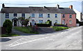
Railway Terrace, Narberth
Row of four houses viewed across Station Approach near Narberth railway station. http://www.geograph.org.uk/photo/4593011
Image: © Jaggery
Taken: 31 Jul 2015
0.01 miles
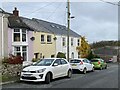
3
Station Approach, Narberth
Dead-end road to Narberth railway station http://www.geograph.org.uk/photo/4593011 viewed across Kiln Park Road.
Image: © Jaggery
Taken: 31 Jul 2015
0.01 miles
4
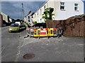
Fenced-off area, Station Approach, Narberth
Viewed on July 31st 2015. The red Amey/Welsh Water notice apologises
for any inconvenience caused during water network maintenance.
Image: © Jaggery
Taken: 31 Jul 2015
0.02 miles
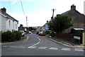
5
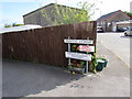
Panteg Uchaf not dedicated as a highway, Narberth
The notice referring to Section 31 of the Highways Act 1980
is on the corner of Station Approach and Panteg Uchaf. http://www.geograph.org.uk/photo/4593604
Image: © Jaggery
Taken: 31 Jul 2015
0.03 miles
6
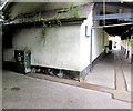
Station electrical main cabinet, Narberth
There is flaking dark green paint on the cabinet on the left. Visible items
powered by cabinet are the electronic display board and the lights under the canopy.
Image: © Jaggery
Taken: 31 Jul 2015
0.03 miles
7
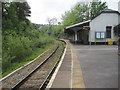
Narberth railway station, Pembrokeshire
Opened in 1866 by the Pembroke & Tenby Railway when they extended their line from Pembroke Dock to Whitland, and who eventually part of the Great Western Railway empire.
View south towards Templeton and Pembroke Dock.
Image: © Nigel Thompson
Taken: 18 May 2014
0.04 miles
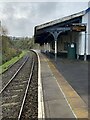
9
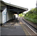
Narberth railway station platform canopy
The canopy is over about a quarter the length of the platform. http://www.geograph.org.uk/photo/4593105
Image: © Jaggery
Taken: 31 Jul 2015
0.04 miles
10
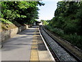
Narberth railway station platform
Viewed from the southern end of the station, looking towards the canopy. http://www.geograph.org.uk/photo/4593097
The small unstaffed single-platform station is a request stop on the Pembroke
Dock branch of the West Wales Line, between Whitland station and Kilgetty station.
Image: © Jaggery
Taken: 31 Jul 2015
0.04 miles