IMAGES TAKEN NEAR TO
Kiln Park Road, NARBERTH, SA67 8TX
Introduction
This page details the photographs taken nearby to Kiln Park Road, SA67 8TX by members of the Geograph project.
The Geograph project started in 2005 with the aim of publishing, organising and preserving representative images for every square kilometre of Great Britain, Ireland and the Isle of Man.

There are currently over 7.5m images from over14,400 individuals and you can help contribute to the project by visiting https://www.geograph.org.uk
Image Map
Images are licensed for reuse under creativecommons.org/licenses/by-sa/2.0
Notes
- Clicking on the map will re-center to the selected point.
- The higher the marker number, the further away the image location is from the centre of the postcode.
Image Listing (41 Images Found)
Images are licensed for reuse under creativecommons.org/licenses/by-sa/2.0
Image
Details
Distance
1
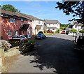
Panteg Uchaf, Narberth
Cul-de-sac on the north side of Station Approach near Narberth railway station.
Image: © Jaggery
Taken: 31 Jul 2015
0.08 miles
3
Station Approach, Narberth
Dead-end road to Narberth railway station http://www.geograph.org.uk/photo/4593011 viewed across Kiln Park Road.
Image: © Jaggery
Taken: 31 Jul 2015
0.11 miles
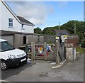
4
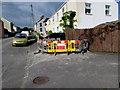
Fenced-off area, Station Approach, Narberth
Viewed on July 31st 2015. The red Amey/Welsh Water notice apologises
for any inconvenience caused during water network maintenance.
Image: © Jaggery
Taken: 31 Jul 2015
0.11 miles
5
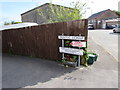
Panteg Uchaf not dedicated as a highway, Narberth
The notice referring to Section 31 of the Highways Act 1980
is on the corner of Station Approach and Panteg Uchaf. http://www.geograph.org.uk/photo/4593604
Image: © Jaggery
Taken: 31 Jul 2015
0.11 miles
6
Station Approach electricity substation, Narberth
Viewed across Station Approach near the Kiln Park Road junction, about 90 metres from Station Road,
despite which the Western Power Distribution electricity substation identifier on the padlocked wooden gate is
STATION ROAD NARBERTH S/S 601648.
Image: © Jaggery
Taken: 31 Jul 2015
0.11 miles
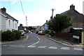
7
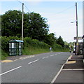
Kiln Park Road bus shelter, Narberth
Viewed from the corner of Station Approach. http://www.geograph.org.uk/photo/4593545
Image: © Jaggery
Taken: 31 Jul 2015
0.12 miles
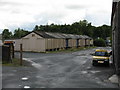
8
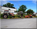
Old tractors and parts, Station Approach, Narberth
A small sample of an area of old tractors and parts of tractors near the NE end of Station Approach.
Image: © Jaggery
Taken: 31 Jul 2015
0.12 miles
9
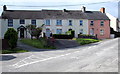
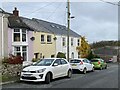
Railway Terrace, Narberth
Row of four houses viewed across Station Approach near Narberth railway station. http://www.geograph.org.uk/photo/4593011
Image: © Jaggery
Taken: 31 Jul 2015
0.12 miles
10
Former Railway Feed Stores, Narberth Station
An unusually long example of the standard 1950s concrete-walled "kit" British Railways grain or feed storehouse, once found in many goods yards. Originally all sides of the structure would have been supported on cylindrical pillars alone, making it difficult for rodents to enter.
Image: © Peter Whatley
Taken: 24 Jul 2009
0.12 miles