IMAGES TAKEN NEAR TO
Pleasant Valley, Stepaside, NARBERTH, SA67 8LR
Introduction
This page details the photographs taken nearby to SA67 8LR by members of the Geograph project.
The Geograph project started in 2005 with the aim of publishing, organising and preserving representative images for every square kilometre of Great Britain, Ireland and the Isle of Man.

There are currently over 7.5m images from over14,400 individuals and you can help contribute to the project by visiting https://www.geograph.org.uk
Image Map
Images are licensed for reuse under creativecommons.org/licenses/by-sa/2.0
Notes
- Clicking on the map will re-center to the selected point.
- The higher the marker number, the further away the image location is from the centre of the postcode.
Image Listing (50 Images Found)
Images are licensed for reuse under creativecommons.org/licenses/by-sa/2.0
Image
Details
Distance
1
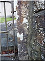
OS benchmark - Stepaside, gatepost of chapel
Located on the stone gatepost of the Methodist Chapel, this OS benchmark was levelled in 1971 at 22.369m above Ordnance Datum Newlyn.
Image: © Richard Law
Taken: 25 Dec 2019
0.02 miles
2
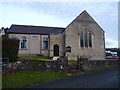
Stepaside Methodist Chapel, Pleasant Valley
The original part of the building (mainly at the rear, here) was built in 1860/61 to a 'long-wall' entry plan, and the gabled extension which faces the road was added in 1893.
Image: © Richard Law
Taken: 25 Dec 2019
0.03 miles
3

Ordnance Survey Cut Mark
This OS cut mark can be found on the gatepost of the Methodist Chapel. It marks a point 22.369m above mean sea level.
Image: © Adrian Dust
Taken: 7 Apr 2022
0.03 miles
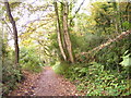
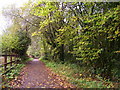
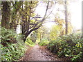
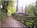
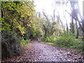
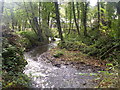
9
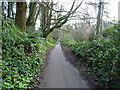
Former railway south of the ironworks
Now converted to a very pleasant footpath through the woods, this section of the former Saundersfoot Railway originally served as a means of transport to and from the nearby ironworks. The line was abandoned in the late 1930s.
Image: © Richard Law
Taken: 25 Dec 2019
0.07 miles