IMAGES TAKEN NEAR TO
Ludchurch, NARBERTH, SA67 8LD
Introduction
This page details the photographs taken nearby to SA67 8LD by members of the Geograph project.
The Geograph project started in 2005 with the aim of publishing, organising and preserving representative images for every square kilometre of Great Britain, Ireland and the Isle of Man.

There are currently over 7.5m images from over14,400 individuals and you can help contribute to the project by visiting https://www.geograph.org.uk
Image Map
Images are licensed for reuse under creativecommons.org/licenses/by-sa/2.0
Notes
- Clicking on the map will re-center to the selected point.
- The higher the marker number, the further away the image location is from the centre of the postcode.
Image Listing (2 Images Found)
Images are licensed for reuse under creativecommons.org/licenses/by-sa/2.0
Image
Details
Distance
1
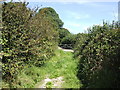
Footpath to Blaencilgoed Quarries
This forms part of the Landsker Borderlands LDF; a circular trail based on Whitland which takes in the countryside of east Carmarthenshire and west Pembrokeshire.
Image: © Jonathan Billinger
Taken: 9 Aug 2007
0.16 miles
2
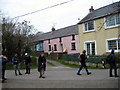
Ger / near Blaengilgoed
Cerddwyr o flaen rhes o fythynnod ger Cwarau Blaengilgoed.
Walkers having a breather in front of a row of cottages near Blaengilgoed Quarries.
Image: © Alan Richards
Taken: 27 Feb 2005
0.18 miles