IMAGES TAKEN NEAR TO
Llawhaden, NARBERTH, SA67 8HH
Introduction
This page details the photographs taken nearby to SA67 8HH by members of the Geograph project.
The Geograph project started in 2005 with the aim of publishing, organising and preserving representative images for every square kilometre of Great Britain, Ireland and the Isle of Man.

There are currently over 7.5m images from over14,400 individuals and you can help contribute to the project by visiting https://www.geograph.org.uk
Image Map
Images are licensed for reuse under creativecommons.org/licenses/by-sa/2.0
Notes
- Clicking on the map will re-center to the selected point.
- The higher the marker number, the further away the image location is from the centre of the postcode.
Image Listing (2 Images Found)
Images are licensed for reuse under creativecommons.org/licenses/by-sa/2.0
Image
Details
Distance
1
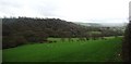
Rural Idyll
Viewed from just above Holgan Fish Farm on the Eastern Cleddau.
Image: © Deborah Tilley
Taken: 3 Apr 2011
0.21 miles
2
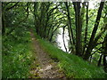
Path high above the Eastern Cleddau in July
What a spot - impossible to pass without stopping and gazing down on the river, as people must have done since Mesolithic times on this spot, it is amazing.
Image: © Jeremy Bolwell
Taken: 11 Jul 2011
0.24 miles