IMAGES TAKEN NEAR TO
Gelli Glas, NARBERTH, SA67 7FJ
Introduction
This page details the photographs taken nearby to Gelli Glas, SA67 7FJ by members of the Geograph project.
The Geograph project started in 2005 with the aim of publishing, organising and preserving representative images for every square kilometre of Great Britain, Ireland and the Isle of Man.

There are currently over 7.5m images from over14,400 individuals and you can help contribute to the project by visiting https://www.geograph.org.uk
Image Map (Loading...)


Getting Data...Please wait
Leaflet Map data © OpenStreetMap
Images are licensed for reuse under creativecommons.org/licenses/by-sa/2.0
Notes
- Clicking on the map will re-center to the selected point.
- The higher the marker number, the further away the image location is from the centre of the postcode.
Image Listing (46 Images Found)
Images are licensed for reuse under creativecommons.org/licenses/by-sa/2.0
Image
Details
Distance
1
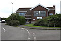
Station Road side of the Radio Pembrokeshire studio in Narberth
Broadcasting at 102.5 FM, the studio is in Unit 14 Old School Estate above Station Road.
Image: © Jaggery
Taken: 31 Jul 2015
0.04 miles
2
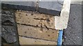
Ordnance Survey Cut Mark
This OS cut mark can be found on the SW angle of the school. It marks a point 107.924m above mean sea level.
Image: © Adrian Dust
Taken: 15 Jan 2017
0.04 miles
3
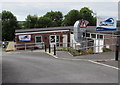
Jellyegg and Spectrum, the Old School Estate, Narberth
Two of the businesses occupying the former Narberth County School are Spectrum Laboratories dental technicial services on the left and Jellyegg footwear and warehouse shop on the right.
Image: © Jaggery
Taken: 31 Jul 2015
0.05 miles
4
Station Road side of the former Narberth County School
The old school buildings are now in various commercial uses. The name Jellyegg (shoe retailer) is on a window.
Image: © Jaggery
Taken: 31 Jul 2015
0.05 miles
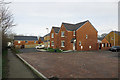
6
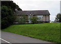
Maesyrodyn, Narberth
There was never a kiln here: the name probably comes from Kilnpark (Parcyrodyn) half a kilometre to the east.
Image: © Dylan Moore
Taken: 23 Dec 2019
0.06 miles
7
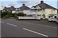
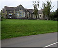
Station Road semis, Narberth
Semi-detached houses on the north side of the B4314 Station Road,
viewed from the corner of John Morgan Close. http://www.geograph.org.uk/photo/4594336
Image: © Jaggery
Taken: 31 Jul 2015
0.06 miles
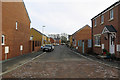
8
John Morgan Close, Narberth
From the Station Road junction. Turn right ahead for the residential part http://www.geograph.org.uk/photo/4594237 of the close or left for Swim Narberth http://www.geograph.org.uk/photo/4594263 and businesses in Old School Estate, formerly Narberth County School.
The Close is named in memory of John Morgan M.A., the school's first headmaster.
Image: © Jaggery
Taken: 31 Jul 2015
0.07 miles
9
Unit to let in Old School Estate, Narberth
Viewed along John Morgan Close. A brown sign points left towards this http://www.geograph.org.uk/photo/4594263 swimming pool.
Image: © Jaggery
Taken: 31 Jul 2015
0.08 miles
10
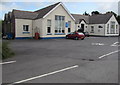
Swim Narberth
Located in the Old School Estate on the south side of Station Road, Narberth. Their website states that Swim Narberth has applied to be a Charitable Incorporated Organisation which means that it is run primarily for the benefit of the community at large, and that all profits are reinvested back into the provision of this community owned and run service.
Swim Narberth aims to be not only the first community owned swimming pool in Pembrokeshire but also the first low carbon one. Its energy needs are met by Narberth Energy, a Community Benefit Society operated in the interests of the people of Narberth and Pembrokeshire.
Image: © Jaggery
Taken: 31 Jul 2015
0.08 miles