IMAGES TAKEN NEAR TO
Old Mart Ground, NARBERTH, SA67 7BR
Introduction
This page details the photographs taken nearby to Old Mart Ground, SA67 7BR by members of the Geograph project.
The Geograph project started in 2005 with the aim of publishing, organising and preserving representative images for every square kilometre of Great Britain, Ireland and the Isle of Man.

There are currently over 7.5m images from over14,400 individuals and you can help contribute to the project by visiting https://www.geograph.org.uk
Image Map
Images are licensed for reuse under creativecommons.org/licenses/by-sa/2.0
Notes
- Clicking on the map will re-center to the selected point.
- The higher the marker number, the further away the image location is from the centre of the postcode.
Image Listing (245 Images Found)
Images are licensed for reuse under creativecommons.org/licenses/by-sa/2.0
Image
Details
Distance
1
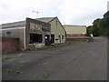
The old Brains Brewery depot, all ready for development
Image: © Shaun Butler
Taken: 25 Sep 2008
0.03 miles
2
What was the old Cattle Market in Narberth
Image: © Shaun Butler
Taken: 25 Sep 2008
0.05 miles
3
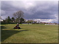
Mowing the cricket field
Preparations are under way for the Narberth cricket season.
Image: © chris whitehouse
Taken: 24 Apr 2012
0.06 miles
4
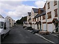
Re-development on old brewery site
Speculation about who and what was happening on this development site had been talked about for some years, now the sign gives all the information and even staff required for the new store.
Image: © chris whitehouse
Taken: 28 Feb 2013
0.07 miles
5
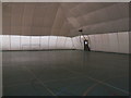
Inside the "giant puffball"
Inside of an inflated sports hall! there are tennis and badminton courts plus other courts and sports areas marked out on the floor, the building is also used by the local emergency services for training etc. Many thanks to the staff of Bloomfield House Community Centre for allowing me to take this photo. This inflated structure is planned to be replaced by a more substantial building and therefore this hall is for sale.
Image: © chris whitehouse
Taken: 7 Nov 2012
0.07 miles
6
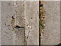
Ordnance Survey Rivet
This OS rivet can be found on the low wall in front of No18 Northfield Road. It marks a point 99.843m above mean sea level.
Image: © Adrian Dust
Taken: 22 Mar 2022
0.07 miles
7
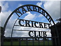
Narberth Cricket Club and sportsground
With facilities for rugby and soccer plus floodlights.
Image: © Natasha Ceridwen de Chroustchoff
Taken: 18 Aug 2007
0.07 miles
8
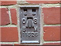
Ordnance Survey Flush Bracket 11526
This can be found on the wall of the Postal Sorting Office.
For more detail see : http://www.bench-marks.org.uk/log?lg_key=61825
Image: © Peter Wood
Taken: 24 May 2013
0.07 miles
9
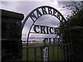
Locked gate to NCC
The cricket ground is through this gate and beyond is the rugby pitch. Football is also played on this field.
Image: © chris whitehouse
Taken: 24 Apr 2012
0.07 miles
10
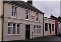
Post Office building
This was the Post Office for Narberth many years ago, then a small "high street" Post Office opened on the High Street about a hundred yards away, this building continued to be Post Office property but as a sorting/ distribution office, not open to the public. this summer the building has been re-painted.
Image: © chris whitehouse
Taken: 7 Nov 2012
0.08 miles