IMAGES TAKEN NEAR TO
Clydach Road, SWANSEA, SA6 6QJ
Introduction
This page details the photographs taken nearby to Clydach Road, SA6 6QJ by members of the Geograph project.
The Geograph project started in 2005 with the aim of publishing, organising and preserving representative images for every square kilometre of Great Britain, Ireland and the Isle of Man.

There are currently over 7.5m images from over14,400 individuals and you can help contribute to the project by visiting https://www.geograph.org.uk
Image Map
Images are licensed for reuse under creativecommons.org/licenses/by-sa/2.0
Notes
- Clicking on the map will re-center to the selected point.
- The higher the marker number, the further away the image location is from the centre of the postcode.
Image Listing (9 Images Found)
Images are licensed for reuse under creativecommons.org/licenses/by-sa/2.0
Image
Details
Distance
1
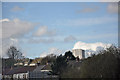
View to Morriston from off J45 on the M4 with the tower of the DVLA
Image: © Mick Lobb
Taken: 11 Apr 2009
0.05 miles
2
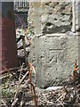
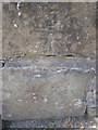
Ordnance Survey Cut Mark
This OS cut mark can be found on the south face buttress of the railway bridge. It marks a point 17.681m above mean sea level.
Image: © Adrian Dust
Taken: 3 Jun 2015
0.06 miles
3
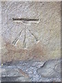
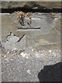
Ordnance Survey Cut Mark
This OS cut mark can be found on the wall of No257 Clydach Road. It marks a point 16.868m above mean sea level.
Image: © Adrian Dust
Taken: 3 Jun 2015
0.09 miles
4
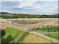
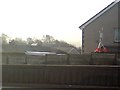
Lower Swansea Valley Flood Scheme Construction
The flood scheme map on site shows improvements to the river embankments from this point for nearly 2km downstream.
Here, the former Park & Ride gravel carpark is being turned into a "Community Recreation Area" at the same time as the existing embankment is being rebuilt further away from the river to create wetland habitat.
Image: © Nigel Davies
Taken: 29 Sep 2013
0.18 miles
5
Ordnance Survey Cut Mark
This OS cut mark can be found on the wall of No197 Clydach Road. It marks a point 16.950m above mean sea level.
Image: © Adrian Dust
Taken: 3 Jun 2015
0.21 miles
6
Pollution monitoring equipment on a house's garage
The curious looking device on a well weighed down tripod seen here on the roof of a house's garage is part of a network of pollution monitoring stations placed in various strategic locations around Swansea.
More information and recent data from this and other monitoring stations can be found at http://test.swansea.airqualitydata.com/cgi-bin/dustsites.cgi .
The picture was taken on the M4 motorway - a pileup just ahead had closed the road and was being cleared to the hard shoulder at the time the picture was taken.
Image: © Hywel Williams
Taken: 25 Feb 2008
0.22 miles
7
Ordnance Survey Cut Mark
This OS cut mark can be found on the wall of No78 Llanllienwen Road. It marks a point 37.990m above mean sea level.
Image: © Adrian Dust
Taken: 3 Jun 2015
0.23 miles
8
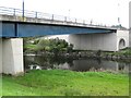
Bridge over Tawe river and paths
The river flows south into the Enterprise Zone and on to Swansea. This relatively new road bridge gives access to the north edge of the zone. A cycle path also runs near the river here
Image: © Nigel Davies
Taken: 22 Sep 2008
0.23 miles
9
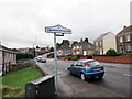
Cwmrhydyceirw
Maestref o Dreforys o'r enw Cwmrhydyceirw. Yn ystod diwygiad crefyddol y 19g fe newidiwyd yr enw gwreddiol 'Cwmrhydycwrw' gan y trigolion parchus i'r un presennol am nad oedd yr enw yn eu tyb nhw'n addas.
Cwmrhydyceirw (trans. valley ford of stags) is a suburb of Morriston. Its original name 'Cwmrhydycwrw' (valley ford of beer) was changed to its present name during the religious revivals of the c19 when respected locals thought that the name was unsuitable.
Image: © Alan Richards
Taken: 27 Feb 2017
0.25 miles