IMAGES TAKEN NEAR TO
Maes Collen, SWANSEA, SA6 6JS
Introduction
This page details the photographs taken nearby to Maes Collen, SA6 6JS by members of the Geograph project.
The Geograph project started in 2005 with the aim of publishing, organising and preserving representative images for every square kilometre of Great Britain, Ireland and the Isle of Man.

There are currently over 7.5m images from over14,400 individuals and you can help contribute to the project by visiting https://www.geograph.org.uk
Image Map (Loading...)


Getting Data...Please wait
Leaflet Map data © OpenStreetMap
Images are licensed for reuse under creativecommons.org/licenses/by-sa/2.0
Notes
- Clicking on the map will re-center to the selected point.
- The higher the marker number, the further away the image location is from the centre of the postcode.
Image Listing (8 Images Found)
Images are licensed for reuse under creativecommons.org/licenses/by-sa/2.0
Image
Details
Distance
1
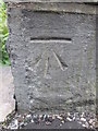
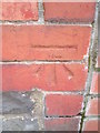
Ordnance Survey Cut Mark
This OS cut mark can be found on the SE parapet of the railway bridge, Vicarage Road. It marks a point 44.47m above mean sea level.
Image: © Adrian Dust
Taken: 3 Jun 2015
0.14 miles
2
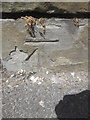
Ordnance Survey Cut Mark
This OS cut mark can be found on the SW facing wall at the junction of Heol y Deri and Chemical Road. It marks a point 49.015m above mean sea level.
Image: © Adrian Dust
Taken: 3 Jun 2015
0.15 miles
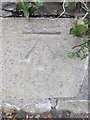
3
Ordnance Survey Cut Mark
This OS cut mark can be found on the wall of No129 Chemical Road. It marks a point 32.254m above mean sea level.
Image: © Adrian Dust
Taken: 3 Jun 2015
0.15 miles
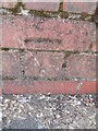
4
Ordnance Survey Cut Mark
This OS cut mark can be found on the wall at the junction of Vicarage Road and Heol Maes y Gelynen. It marks a point 51.676m above mean sea level.
Image: © Adrian Dust
Taken: 3 Jun 2015
0.15 miles
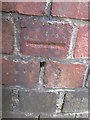
5
Ordnance Survey Cut Mark
This OS cut mark can be found on the wall post of No149 Llanllienwen Road. It marks a point 54.492m above mean sea level.
Image: © Adrian Dust
Taken: 3 Jun 2015
0.22 miles
6
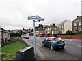
Cwmrhydyceirw
Maestref o Dreforys o'r enw Cwmrhydyceirw. Yn ystod diwygiad crefyddol y 19g fe newidiwyd yr enw gwreddiol 'Cwmrhydycwrw' gan y trigolion parchus i'r un presennol am nad oedd yr enw yn eu tyb nhw'n addas.
Cwmrhydyceirw (trans. valley ford of stags) is a suburb of Morriston. Its original name 'Cwmrhydycwrw' (valley ford of beer) was changed to its present name during the religious revivals of the c19 when respected locals thought that the name was unsuitable.
Image: © Alan Richards
Taken: 27 Feb 2017
0.22 miles
7
Ordnance Survey Cut Mark
This OS cut mark can be found on the wall of No78 Llanllienwen Road. It marks a point 37.990m above mean sea level.
Image: © Adrian Dust
Taken: 3 Jun 2015
0.24 miles
8
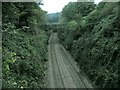
Railway line at Cwmrhydyceirw
This is the view west from a bridge at the north end of Vicarage Road. The area is so dense and built up that this railway goes unnoticed, being cut so deep and narrow. In the distance you can see the west entrance of the Llangyfelach tunnel.
Image: © Nigel Davies
Taken: 6 Oct 2005
0.25 miles