IMAGES TAKEN NEAR TO
Mynachlogddu, CLYNDERWEN, SA66 7SD
Introduction
This page details the photographs taken nearby to SA66 7SD by members of the Geograph project.
The Geograph project started in 2005 with the aim of publishing, organising and preserving representative images for every square kilometre of Great Britain, Ireland and the Isle of Man.

There are currently over 7.5m images from over14,400 individuals and you can help contribute to the project by visiting https://www.geograph.org.uk
Image Map
Images are licensed for reuse under creativecommons.org/licenses/by-sa/2.0
Notes
- Clicking on the map will re-center to the selected point.
- The higher the marker number, the further away the image location is from the centre of the postcode.
Image Listing (12 Images Found)
Images are licensed for reuse under creativecommons.org/licenses/by-sa/2.0
Image
Details
Distance
1
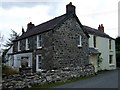
Ty Canol in Mynachclog-ddu
House in the village street with stones on the wall.
Image: © Natasha Ceridwen de Chroustchoff
Taken: 16 Aug 2009
0.01 miles
2
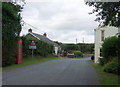
Entering Mynachlog-ddu
The name of this remote Preseli village is usually thought to derive from the Welsh for 'black monks' but it has also been suggested it may be a corruption of mynach Llandudoch/the monks of Llandudoch which is the Welsh name for St Dogmael's where there is an abbey to which the village belonged (the same saint also the patron of the parish church).
Image: © Natasha Ceridwen de Chroustchoff
Taken: 16 Aug 2009
0.05 miles
3
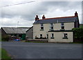
Ffynnon-wen
Farm at a road junction just west of Mynachlog-ddu. The name means white, or blessed, spring - it can still be seen in emerging from the bank opposite.
Image: © Natasha Ceridwen de Chroustchoff
Taken: 16 Aug 2009
0.12 miles
4
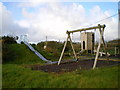
Children's playground in Mynachlog-ddu
The playground has recently been refurbished. Bird boxes have been attached to various parts of the equipment too, such as the one on the corner of the wooden 'castle' at the back. This begs the question as to how well the nestboxes are used if the playground is in regular use in the springtime?
Image: © Richard Law
Taken: 28 Oct 2008
0.13 miles
5
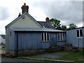
Tin extension in Mynachlog-ddu
Not unusual to find these corrugated metal structures in this area - a cheap and practical way to build in the mid C20.
Image: © Natasha Ceridwen de Chroustchoff
Taken: 16 Aug 2009
0.15 miles
6
Former garage in Mynachlog-ddu
My guidebook said the village also had a post office, but that has closed too.
Image: © Bill Boaden
Taken: 24 Aug 2011
0.15 miles
7
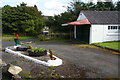
The baptistry of Bethel Chapel
In common with many churches in the area, this has an outdoor baptistry, located in a wooded glade in the village.
Image: © Bill Boaden
Taken: 24 Aug 2011
0.17 miles
8
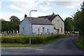
Bethel Chapel, Mynachlog-ddu
This is the only church in the village and there is no Anglican church locally. The building has been rebuilt twice since the original one from 1794, with a subsequent refurbishment in 1940.
Image: © Bill Boaden
Taken: 24 Aug 2011
0.21 miles
9
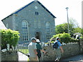
Capel Bethel, Mynachlog Ddu
Cerddwyr yn mynd heibio i Gapel Bethel, Mynachlog Ddu a adeiladwyd yn gyntaf yn 1794. Yn y fynwent y gorwedd olion Twm Carnabwth, arweinydd enwog Merched Beca.
Walkers passing Bethel Chapel, Mynachlog Ddu (trans. dark, bleak monastic grange) which was first built in 1794. In the graveyard one can find the final resting place of Twm Carnabwth, a famous leader of the Rebecca Riots.
Image: © Alan Richards
Taken: 24 May 2009
0.22 miles
10
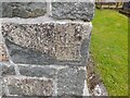
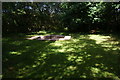
Ordnance Survey Cut Mark
This OS cut mark can be found on the SW angle of Capel Bethel. It marks a point 193.259m above mean sea level.
Image: © Adrian Dust
Taken: 12 May 2022
0.22 miles