IMAGES TAKEN NEAR TO
High Street, SWANSEA, SA6 5LQ
Introduction
This page details the photographs taken nearby to High Street, SA6 5LQ by members of the Geograph project.
The Geograph project started in 2005 with the aim of publishing, organising and preserving representative images for every square kilometre of Great Britain, Ireland and the Isle of Man.

There are currently over 7.5m images from over14,400 individuals and you can help contribute to the project by visiting https://www.geograph.org.uk
Image Map (Loading...)


Getting Data...Please wait
Leaflet Map data © OpenStreetMap
Images are licensed for reuse under creativecommons.org/licenses/by-sa/2.0
Notes
- Clicking on the map will re-center to the selected point.
- The higher the marker number, the further away the image location is from the centre of the postcode.
Image Listing (23 Images Found)
Images are licensed for reuse under creativecommons.org/licenses/by-sa/2.0
Image
Details
Distance
1
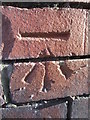
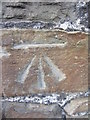
Ordnance Survey Cut Mark
This OS cut mark can be found on the Post Office, No43 High Street. It marks a point 27.938m above mean sea level.
Image: © Adrian Dust
Taken: 28 Dec 2013
0.01 miles
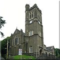
2
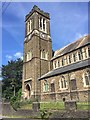
St.Mary's Church, Clydach
St.Mary's Church, founded in 1905.
Image: © Alan Hughes
Taken: 1 Jul 2017
0.06 miles
4
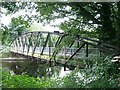
Footbridge over River Tawe at Clydach
This bridge allows access to the playing fields Image on the other side of the river.
Image: © Nigel Davies
Taken: 16 Aug 2009
0.11 miles
5
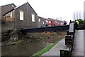
Mineral line bridge over Tawe
The dismantled mineral line that used to run into the Mond refinery (now the Inco works Image) is now blocked off at the works fence. You can still get on to the bridge to look at the river though.
Image: © Nigel Davies
Taken: 16 Aug 2009
0.12 miles
6
Afon Tawe Bridge, Clydach
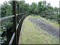
Renowned for its artwork, the newly opened Afon Tawe Bridge has opened up the old industrial valley for local walkers, cyclists and general leisure use.
Image: © Kevin Corcoran
Taken: 14 Oct 2014
0.12 miles
7
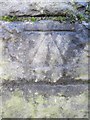
Ordnance Survey Cut Mark
This OS cut mark can be found on the SE face of Clydach Bridge. It marks a point 21.299m above mean sea level.
Image: © Adrian Dust
Taken: 28 Dec 2013
0.12 miles
8
Camlas Clydach Canal
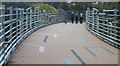
Cerddwyr yn croesi pontdroed a rychwanta Gamlas Abertawe. Adeiladwyd y gamlas rhwng 1794 a 1798 o Abercraf i Abertawe, pellter o 16 milltir a chludid glo, dur a haearn arni. Fe'i caewyd yn 1931. Yn 1981 sefydlwyd Cymdeithas Gamlas Abertawe er mwyn ei hadfer. Y capel yn y cefndir yw Calfaria.
Walkers crossing a footbridge spanning the Swansea Canal. The canal, built between 1794 and 1798 and sixteen miles in length, linked Abercraf with Swansea and transported mainly coal, steel and iron. The canal finally closed in 1931. In 1981 the Swansea Canal Society was formed and is committed in restoring the old waterway.
Image: © Alan Richards
Taken: 26 Jan 2014
0.12 miles
9
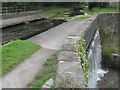
Swansea Canal overflows into Lower Clydach River
Just don't ask what the water level is.
The aqueduct here is also a handy overflow maintaining the level in the canal. The excess falls down into the Lower Clydach River just before it joins the Tawe.
Image: © Nigel Davies
Taken: 16 Aug 2009
0.12 miles
10
Ordnance Survey Cut Mark
This OS cut mark can be found on No44 Lower Down Road. It marks a point 29.928m above mean sea level.
Image: © Adrian Dust
Taken: 28 Dec 2013
0.13 miles