IMAGES TAKEN NEAR TO
Langer Way, SWANSEA, SA6 5JX
Introduction
This page details the photographs taken nearby to Langer Way, SA6 5JX by members of the Geograph project.
The Geograph project started in 2005 with the aim of publishing, organising and preserving representative images for every square kilometre of Great Britain, Ireland and the Isle of Man.

There are currently over 7.5m images from over14,400 individuals and you can help contribute to the project by visiting https://www.geograph.org.uk
Image Map
Images are licensed for reuse under creativecommons.org/licenses/by-sa/2.0
Notes
- Clicking on the map will re-center to the selected point.
- The higher the marker number, the further away the image location is from the centre of the postcode.
Image Listing (3 Images Found)
Images are licensed for reuse under creativecommons.org/licenses/by-sa/2.0
Image
Details
Distance
1
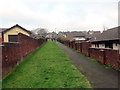
Llwybr drwy ystad o dai / Path through a housing estate
Llwybr yn mynd drwy ystad o dai tuag at Heol Gellionnen.
A path heading through a housing estate towards Gellionnen Road (trans. ash grove).
Image: © Alan Richards
Taken: 31 Dec 2019
0.02 miles
2
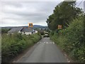
Speed Restrictions at Penydre
20 mph speed restriction on approaching Penydre, Clydach.
Image: © Alan Hughes
Taken: 1 Jul 2017
0.17 miles
3
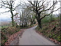
Heol Gellionnen / Gellionnen Road
Heol fach yn agosau at anheddiad ar gyrion Clydach.
A minor road approaching a settlement on the outskirts of Clydach
Image: © Alan Richards
Taken: 31 Dec 2019
0.23 miles