IMAGES TAKEN NEAR TO
Faraday Road, SWANSEA, SA6 5JS
Introduction
This page details the photographs taken nearby to Faraday Road, SA6 5JS by members of the Geograph project.
The Geograph project started in 2005 with the aim of publishing, organising and preserving representative images for every square kilometre of Great Britain, Ireland and the Isle of Man.

There are currently over 7.5m images from over14,400 individuals and you can help contribute to the project by visiting https://www.geograph.org.uk
Image Map
Images are licensed for reuse under creativecommons.org/licenses/by-sa/2.0
Notes
- Clicking on the map will re-center to the selected point.
- The higher the marker number, the further away the image location is from the centre of the postcode.
Image Listing (5 Images Found)
Images are licensed for reuse under creativecommons.org/licenses/by-sa/2.0
Image
Details
Distance
1
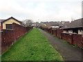
Llwybr drwy ystad o dai / Path through a housing estate
Llwybr yn mynd drwy ystad o dai tuag at Heol Gellionnen.
A path heading through a housing estate towards Gellionnen Road (trans. ash grove).
Image: © Alan Richards
Taken: 31 Dec 2019
0.10 miles
2
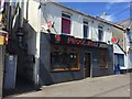
Phool Koli
Bangladeshi Takeaway in Clydach.
Image: © Alan Hughes
Taken: 1 Jul 2017
0.17 miles
3
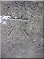
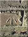
Ordnance Survey Cut Mark
This OS cut mark can be found on the wall, once a bridge parapet, to the NE of the road. It marks a point 54.864m above mean sea level.
Image: © Adrian Dust
Taken: 17 Mar 2014
0.19 miles
4
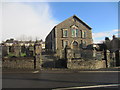
Salem Chapel
Calvanistic Methodist Chapel on Lone Road. http://www.geograph.org.uk/photo/3792307
Image: © Adrian Dust
Taken: 28 Dec 2013
0.20 miles
5
Ordnance Survey Cut Mark
This OS cut mark can be found on the gatepost of the Chapel cemetery. It marks a point 48.280m above mean sea level. http://www.geograph.org.uk/photo/3792311
Image: © Adrian Dust
Taken: 28 Dec 2013
0.21 miles