IMAGES TAKEN NEAR TO
Pontfaen, FISHGUARD, SA65 9TT
Introduction
This page details the photographs taken nearby to SA65 9TT by members of the Geograph project.
The Geograph project started in 2005 with the aim of publishing, organising and preserving representative images for every square kilometre of Great Britain, Ireland and the Isle of Man.

There are currently over 7.5m images from over14,400 individuals and you can help contribute to the project by visiting https://www.geograph.org.uk
Image Map
Images are licensed for reuse under creativecommons.org/licenses/by-sa/2.0
Notes
- Clicking on the map will re-center to the selected point.
- The higher the marker number, the further away the image location is from the centre of the postcode.
Image Listing (4 Images Found)
Images are licensed for reuse under creativecommons.org/licenses/by-sa/2.0
Image
Details
Distance
1
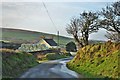
Trewern Farm Near Pontfaen
Situated on a quiet lane a few miles off the main Cardigan to Haverfordwest road and leading to Pontfaen
Image: © Deborah Tilley
Taken: 28 Dec 2015
0.00 miles
2
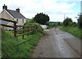
Road to Pontfaen
A minor road runs past Trewern farm, around the slope of Banc Ty-Canol, dipping down to Pontfaen and providing a link between the Gwaun valley and the B4329. In the distance can be seen the contours of the coast to the west.
Image: © Natasha Ceridwen de Chroustchoff
Taken: 24 Jun 2007
0.02 miles
3
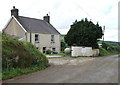
Trewern farm, Pontfaen
On older maps this farm is named Ty'r Wern/House by the swamp (or alder-trees, which grow on wet land): this would be where the Pontfaen brook runs down the valley behind, to the southwest.
Image: © Natasha Ceridwen de Chroustchoff
Taken: 24 Jun 2007
0.03 miles
4
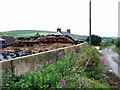
Silage heap and foxgloves at Trewern
Hillside dairy farm on a narrow road across the valley from Pontfaen.
Mid June and last year's silage is almost gone.
Image: © Natasha Ceridwen de Chroustchoff
Taken: 24 Jun 2007
0.03 miles