IMAGES TAKEN NEAR TO
Pontfaen, FISHGUARD, SA65 9SB
Introduction
This page details the photographs taken nearby to SA65 9SB by members of the Geograph project.
The Geograph project started in 2005 with the aim of publishing, organising and preserving representative images for every square kilometre of Great Britain, Ireland and the Isle of Man.

There are currently over 7.5m images from over14,400 individuals and you can help contribute to the project by visiting https://www.geograph.org.uk
Image Map
Images are licensed for reuse under creativecommons.org/licenses/by-sa/2.0
Notes
- Clicking on the map will re-center to the selected point.
- The higher the marker number, the further away the image location is from the centre of the postcode.
Image Listing (19 Images Found)
Images are licensed for reuse under creativecommons.org/licenses/by-sa/2.0
Image
Details
Distance
1
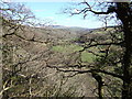
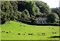
Cwm Gwaun, view towards the Preselis
Photograph taken looking south-east.The floor of this glacial valley has sheltered fields and scattered houses/farms but the slopes are densely wooded. The local community remains largely Welsh-speaking with its own dialect and even celebrates Christmas according to the old calendar.
Image: © Natasha Ceridwen de Chroustchoff
Taken: 5 Apr 2006
0.01 miles
2
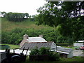
Farm near Cilrhedyn Bridge
The farm is perched just above the road which crosses Afon Gwaun a short distance away. A walking route passes through the farm yard.
Image: © Natasha Ceridwen de Chroustchoff
Taken: 14 Jul 2010
0.02 miles
4
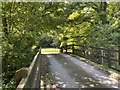
Cilrhedyn Bridge
Bridge over Afon Gwaun at Cilrhedyn.
Image: © Alan Hughes
Taken: 24 Jun 2020
0.04 miles
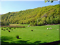
5
Dolhaidd seen from the northwest
Small riverside dwelling near Cilrhedyn Bridge with a long history of habitation. The name means 'barley meadow' which was in the area shown here. The Afon Gwaun runs along the edge of the field, right in this view, with a public footpath on the left below the woods.
Image: © Natasha Ceridwen de Chroustchoff
Taken: 2 Oct 2016
0.04 miles
7
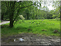
Cilrhedyn bridge picnic area
By a small car park.
Image: © Hugh Venables
Taken: 30 May 2014
0.06 miles
8
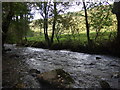
Afon Gwaun at Cilrhedyn
The river flowing strongly away from the bridge on its way to the sea at Lower Fishguard.
Image: © Natasha Ceridwen de Chroustchoff
Taken: 12 Oct 2009
0.06 miles
9
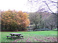
Cilrhedyn bridge picnic area in the Gwaun Valley
Cilrhedyn means something like 'fern hollow'. The bridge crosses the Afon Gwaun.
Image: © Natasha Ceridwen de Chroustchoff
Taken: 12 Nov 2006
0.07 miles
10
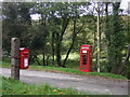
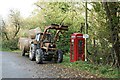
Postbox and phonebox, Cilrhedyn
Good to see traditional communication systems still operative in Cwm Gwaun especially since mobile phones cannot be relied upon to work in the valley.
Image: © Natasha Ceridwen de Chroustchoff
Taken: 12 Oct 2009
0.08 miles