IMAGES TAKEN NEAR TO
Marchgate Paddock, FISHGUARD, SA65 9NU
Introduction
This page details the photographs taken nearby to Marchgate Paddock, SA65 9NU by members of the Geograph project.
The Geograph project started in 2005 with the aim of publishing, organising and preserving representative images for every square kilometre of Great Britain, Ireland and the Isle of Man.

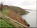
There are currently over 7.5m images from over14,400 individuals and you can help contribute to the project by visiting https://www.geograph.org.uk
Image Map
Images are licensed for reuse under creativecommons.org/licenses/by-sa/2.0
Notes
- Clicking on the map will re-center to the selected point.
- The higher the marker number, the further away the image location is from the centre of the postcode.
Image Listing (109 Images Found)
Images are licensed for reuse under creativecommons.org/licenses/by-sa/2.0
Image
Details
Distance
1
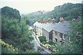
The Slade, Fishguard
looking east from Penslade, off West Street
Image: © Andrew Longton
Taken: 23 Jun 2004
0.06 miles
2
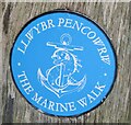
Fishguard - The Marine Walk
Llwybr Pencowrw - waymarker on the coastal path from Fishguard's Lower Town, around Saddle Point, to Goodwick.
www.gofishguard.co.uk
Image: © Colin Smith
Taken: 4 Oct 2021
0.12 miles
3
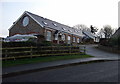
Old Drill Hall
Recently converted into specialist holiday accommodation, this was Fishguard's old Territorial Army drill hall perched high above the bay.
Image: © Natasha Ceridwen de Chroustchoff
Taken: 15 Dec 2008
0.12 miles
4
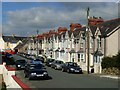
Victoria Avenue, Fishguard
A typical street of terraced houses to the west of the town centre.
Image: © Stephen McKay
Taken: 24 Jul 2006
0.12 miles
5
Coast at Fishguard
The coast path runs above Lampit Bach, following footpath PP19 42.
Image: © Derek Harper
Taken: 31 Dec 2014
0.13 miles
6
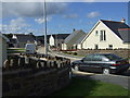
New build, Abergwaun/Fishguard
An estate of 28 small houses and bungalows being built in the Windy Hall area of Fishguard.
Image: © Natasha Ceridwen de Chroustchoff
Taken: 6 Jan 2007
0.14 miles
7
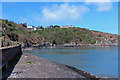
Lampit Mawr
Viewed from the Cwm harbour breakwater. Rather an odd place name; it was Llan pit on the 1844 tithe map, but is neither llan nor pit. The headland remained un-populated until well into the 20th century.
Image: © Dylan Moore
Taken: 10 May 2018
0.14 miles
8
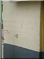
Foundation stone and benchmark on Theatr Gwaun, Fishguard
Image: © Richard Law
Taken: 3 Apr 2010
0.15 miles
9
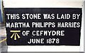
Stone in corner of Theatr Gwaun
Part of stone commemorating Temperance Movement in Fishguard.
Image: © Arthur C Harris
Taken: 24 Apr 2018
0.15 miles
10
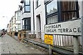
Vergam Terrace/Y Byrgam
Terrace of bow-fronted houses built when the town was expanding, probably early 20th century.
No information appears to exist about the name Vergam but the suggestion has been made that the area could have been known as Y Byr Gam, meaning a short step in Welsh.
Image: © Natasha Ceridwen de Chroustchoff
Taken: 12 Oct 2023
0.15 miles