IMAGES TAKEN NEAR TO
Heol Caradog, FISHGUARD, SA65 9AY
Introduction
This page details the photographs taken nearby to Heol Caradog, SA65 9AY by members of the Geograph project.
The Geograph project started in 2005 with the aim of publishing, organising and preserving representative images for every square kilometre of Great Britain, Ireland and the Isle of Man.

There are currently over 7.5m images from over14,400 individuals and you can help contribute to the project by visiting https://www.geograph.org.uk
Image Map (Loading...)


Getting Data...Please wait
Leaflet Map data © OpenStreetMap
Images are licensed for reuse under creativecommons.org/licenses/by-sa/2.0
Notes
- Clicking on the map will re-center to the selected point.
- The higher the marker number, the further away the image location is from the centre of the postcode.
Image Listing (14 Images Found)
Images are licensed for reuse under creativecommons.org/licenses/by-sa/2.0
Image
Details
Distance
1
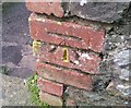
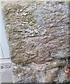
Ordnance Survey Cut Mark
This OS cut mark can be found on the wall of Pen Groes House. It marks a point 69.440m above mean sea level.
Image: © Adrian Dust
Taken: 4 Mar 2020
0.13 miles
2
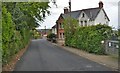
B Road From Llanychaer
Entering the small town of Fishguard
Image: © Deborah Tilley
Taken: 25 May 2015
0.13 miles
3
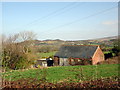
Gwynfa bottling plant
The derelict remains of a laundry, on the site of Bateman's mineral water bottling plant, in Plas-y-fron on the eastern edge of Fishguard. The spring from which the water was obtained is across this field but appears to be overgrown and fenced off.
Image: © Natasha Ceridwen de Chroustchoff
Taken: 1 Mar 2011
0.16 miles
4
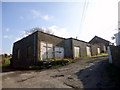
Old bottling plant/laundry, Plas-y-fron
The site of Gwynfa mineral water works which produced bottled water obtained from a spring in the field. Subsequently there was a laundry here.
It's the last building when leaving Fishguard on the Llanychaer road.
Update (2012): building now destroyed prior to redevelopment of the site for housing.
Image: © Natasha Ceridwen de Chroustchoff
Taken: 1 Mar 2011
0.17 miles
5
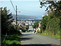
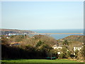
Pen Wallis, looking north to Fishguard Bay
This is the highest point of the town, on the southern edge, looking down Wallis Street and out towards the harbour at Goodwick.
Much of the housing in this area dates from the latter part of the C20.
Image: © Natasha Ceridwen de Chroustchoff
Taken: 22 Aug 2007
0.18 miles
6
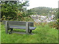
Fishguard - Viewpoint
Bench on Tower Hill overlooking Lower Town and historic harbour.
www.gofishguard.co.uk
Image: © Colin Smith
Taken: 4 Oct 2021
0.19 miles
7
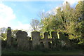
Old tannery, Tower Hill
Ruins only remain but there is a planning application to restore and convert (2019)
Image: © Natasha Ceridwen de Chroustchoff
Taken: 23 Oct 2019
0.21 miles
8
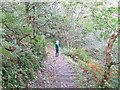
Fishguard - Tower Hill
Steps descending the wooded hill to the valley of the River Gwaun.
www.gofishguard.co.uk
Image: © Colin Smith
Taken: 4 Oct 2021
0.23 miles
9
View from above Plas-y-fron
The houses up above Plas-y-fron enjoy a fine view north over the Fishguard bay and the harbour at Goodwick.
Image: © Natasha Ceridwen de Chroustchoff
Taken: 1 Mar 2011
0.23 miles
10
Ordnance Survey Cut Mark
This OS cut mark can be found on the garage at Prospect House. It marks a point 81.226m above mean sea level.
Image: © Adrian Dust
Taken: 4 Mar 2020
0.23 miles