IMAGES TAKEN NEAR TO
Bryn Llewellyn, FISHGUARD, SA65 9AX
Introduction
This page details the photographs taken nearby to Bryn Llewellyn, SA65 9AX by members of the Geograph project.
The Geograph project started in 2005 with the aim of publishing, organising and preserving representative images for every square kilometre of Great Britain, Ireland and the Isle of Man.

There are currently over 7.5m images from over14,400 individuals and you can help contribute to the project by visiting https://www.geograph.org.uk
Image Map
Images are licensed for reuse under creativecommons.org/licenses/by-sa/2.0
Notes
- Clicking on the map will re-center to the selected point.
- The higher the marker number, the further away the image location is from the centre of the postcode.
Image Listing (20 Images Found)
Images are licensed for reuse under creativecommons.org/licenses/by-sa/2.0
Image
Details
Distance
1
Pen Wallis, looking north to Fishguard Bay
This is the highest point of the town, on the southern edge, looking down Wallis Street and out towards the harbour at Goodwick.
Much of the housing in this area dates from the latter part of the C20.
Image: © Natasha Ceridwen de Chroustchoff
Taken: 22 Aug 2007
0.06 miles
2
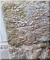
Ordnance Survey Cut Mark
This OS cut mark can be found on the garage at Prospect House. It marks a point 81.226m above mean sea level.
Image: © Adrian Dust
Taken: 4 Mar 2020
0.16 miles
3
Recycling for the Sally Ann
Donated clothing receptacles being swopped, empty for full, in the carpark.
Image: © Natasha Ceridwen de Chroustchoff
Taken: 22 Dec 2009
0.18 miles
4
Former National School, Hamilton Street
Old C19 (girls?) voluntary/board school tucked away next to its schoolmaster's house. The plaque, barely legible, states it was erected in memory of Sir James John Hamilton, Bart. by his devoted widow in 1886. The family had already donated land for an earlier (boys?) school over the road, see https://www.geograph.org.uk/photo/7208821
Image: © Natasha Ceridwen de Chroustchoff
Taken: 9 Dec 2006
0.20 miles
5
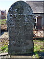
The toll taken by the sea
Three members of the same family are commemorated on this gravestone in the Tabernacle cemetery. Henry Lewis of the brigantine Gwladys who was drowned in the Bristol Channel in December 1891 (while en route from Cardiff to Messina with a cargo of coal the ship was rammed by a steamer off Hartland Point and went down, 3 of the 7 men were lost); brothers David and Arthur were lost in the South Atlantic in 1907 when en route from Bahia Blanca to Antwerp with a cargo of wheat. Their ship S.S. Dulverton was posted missing, last seen hove to with engine trouble. They were both in their 20s, sons of John and Tamar Lewis of Fishguard.
Image: © Natasha Ceridwen de Chroustchoff
Taken: 1 Mar 2011
0.20 miles
6
View from Tabernacle cemetery
Looking west towards the backs of houses in Wallis Street, from the graveyard behind Tabernacle.
Image: © Natasha Ceridwen de Chroustchoff
Taken: 1 Mar 2011
0.20 miles
8
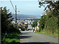
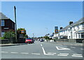
B Road From Llanychaer
Entering the small town of Fishguard
Image: © Deborah Tilley
Taken: 25 May 2015
0.21 miles
9
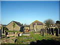
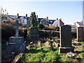
Tabernacle cemetery
The graveyard behind the chapel in Park Street.
Image: © Natasha Ceridwen de Chroustchoff
Taken: 1 Mar 2011
0.21 miles
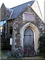
10
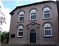
Tabernacle Independent Chapel
In Park Street, on the eastern side of the town. Built 1845, it fronts the street with a hall behind.
Image: © Natasha Ceridwen de Chroustchoff
Taken: 14 Jul 2007
0.21 miles