1
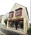
Theatr Gwaun
Fishguard's cinema (public and film club) since 1926, theatre (since 1994) and venue for other live entertainment. The W.I. country market also takes place here.
In its earlier incarnation (1881) it was a Temperance Hall.
Image: © Natasha Ceridwen de Chroustchoff
Taken: 31 Oct 2006
0.05 miles
2
Reminder of the Temperance Movement in Fishguard
Located in what now is Theatr Gwaun.
Image: © Arthur C Harris
Taken: 24 Apr 2018
0.05 miles
3
Bethel English Baptist Church, Fishguard
Bethel English Baptist Church,West Street,Fishguard.
Image: © Arthur C Harris
Taken: 5 Oct 2014
0.05 miles
4
Roofs in The Slade
Looking down the hill from Penslade the roofs of houses and cottages in The Slade can be seen descending in stepped formation. One or two of them may date back 200 years - there were thriving fishing and boat building industries in the harbour below as well as two lime kilns.
The wooded area behind is the steep bank behind St Mary's church (belfry visible above).
Image: © Natasha Ceridwen de Chroustchoff
Taken: 9 Jun 2010
0.05 miles
5
Houses in The Slade
Tightly packed houses on one side of The Slade, a steep street going down to the old harbour. The name, which is not Welsh, is usually said to derive from an Old English word for valley or slope, alternatively it has been suggested that it was related to slide since boats were once built and launched at the bottom of the hill.
Beyond, houses can be seen on higher ground in West Street.
Image: © Natasha Ceridwen de Chroustchoff
Taken: 9 Jun 2010
0.05 miles
6
The Fishguard Bethel English Chapel
Built in the late 1900s, and located on West Street.
Image: © Richard Law
Taken: 19 Sep 2019
0.06 miles
7
Fishguard - Tenby House
Old building on West Street, now housing a newsagent.
Image: © Colin Smith
Taken: 4 Oct 2021
0.06 miles
8
The Gourmet Pig at Fishguard
Located at the corner of West Street and Penslade. The Gourmet Pig, Fishguard, Pembrokeshire.
Image: © Arthur C Harris
Taken: 13 Oct 2013
0.06 miles
9
Bethel English Baptist chapel
Chapel built 1908 in West Street, situated close to the former temperance hall (now a theatre/cinema).
Image: © Natasha Ceridwen de Chroustchoff
Taken: 31 Oct 2006
0.06 miles
10
West Street businesses
Insurance in the foreground, with butcher and hairdresser to the left.
Image: © Natasha Ceridwen de Chroustchoff
Taken: 20 Nov 2008
0.06 miles


