IMAGES TAKEN NEAR TO
Dyffryn, GOODWICK, SA64 0AN
Introduction
This page details the photographs taken nearby to Dyffryn, SA64 0AN by members of the Geograph project.
The Geograph project started in 2005 with the aim of publishing, organising and preserving representative images for every square kilometre of Great Britain, Ireland and the Isle of Man.

There are currently over 7.5m images from over14,400 individuals and you can help contribute to the project by visiting https://www.geograph.org.uk
Image Map
Images are licensed for reuse under creativecommons.org/licenses/by-sa/2.0
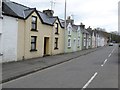
Notes
- Clicking on the map will re-center to the selected point.
- The higher the marker number, the further away the image location is from the centre of the postcode.
Image Listing (25 Images Found)
Images are licensed for reuse under creativecommons.org/licenses/by-sa/2.0
Image
Details
Distance
1
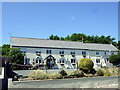
The Ferryboat Inn, Wdig/Goodwick
Inn and restaurant in Dyffryn, about half a kilometre from the ferry terminal.
Image: © Natasha Ceridwen de Chroustchoff
Taken: 24 Jun 2010
0.01 miles
3
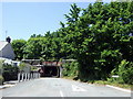
Jackson's Lane railway bridge
The line crosses the road here via a bridge only 7ft 9 ins in height.
Image: © Natasha Ceridwen de Chroustchoff
Taken: 24 Jun 2010
0.07 miles
4
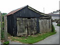
Garage, Dyffryn
Nice specimen of typical corrugated iron structure with dilapidated doors and traditional brick door stop!
Similar examples could be found in many parts of the world.
Image: © Natasha Ceridwen de Chroustchoff
Taken: 9 Jun 2010
0.07 miles
5
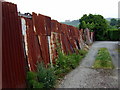
Corrugated iron fence
A classic example! Below Kensington Street, Goodwick.
The building on the skyline is Ysgol Bro Gwaun on the other side of Goodwick Moor.
Image: © Natasha Ceridwen de Chroustchoff
Taken: 9 Jun 2010
0.08 miles
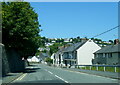
6
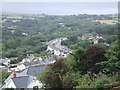
View over Dyffryn
Going up from the centre of Goodwick/Wdig towards Stop and Call, a view opens to the south of Dyffryn and the curving terrace of Heol y Felin. This section of road was relieved of its heavy, nocturnal, ferry-bound traffic by the construction of a new by-pass a few years ago.
Image: © Natasha Ceridwen de Chroustchoff
Taken: 9 Aug 2006
0.12 miles
7
Classic Car Rally Heads Through Goodwick
Heading for the seafront and a warm coffee in the cafe!
Image: © Deborah Tilley
Taken: 6 Sep 2015
0.12 miles
8
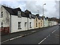
Terraced houses
Row of terraced houses, Dyffryn.
Image: © Alan Hughes
Taken: 7 Nov 2017
0.13 miles
9
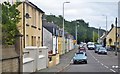
Cottage row
Proceeding out of Goodwick on Wern Road one passes dreary wholesalers and builders merchants, until suddenly the 'suburb' of Dyffryn is reached with its much older and more charming houses on both sides of the road.
Image: © Jonathan Wilkins
Taken: 1 Apr 2016
0.13 miles
10
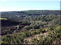
Long view towards Goodwick and Pencaer
An exceptionally clear afternoon produces a remarkably long vista: in the foreground, the scrubby slope leading down to Cwm Brandy and, beyond the wooded area, the western part of Goodwick along the A487 St David's road. Above, just visible, are the farms of Trefwrgi (right) and Tre-Llewelyn (left, amongst dark trees), while the pimple on the skyline is the highest point on Pencaer, at 213 metres, the rocky peak of Garn Fawr on the west-facing coast.
Image: © Natasha Ceridwen de Chroustchoff
Taken: 11 Feb 2009
0.14 miles