IMAGES TAKEN NEAR TO
Tufton, CLARBESTON ROAD, SA63 4TJ
Introduction
This page details the photographs taken nearby to SA63 4TJ by members of the Geograph project.
The Geograph project started in 2005 with the aim of publishing, organising and preserving representative images for every square kilometre of Great Britain, Ireland and the Isle of Man.

There are currently over 7.5m images from over14,400 individuals and you can help contribute to the project by visiting https://www.geograph.org.uk
Image Map (Loading...)


Getting Data...Please wait
Leaflet Map data © OpenStreetMap
Images are licensed for reuse under creativecommons.org/licenses/by-sa/2.0
Notes
- Clicking on the map will re-center to the selected point.
- The higher the marker number, the further away the image location is from the centre of the postcode.
Image Listing (3 Images Found)
Images are licensed for reuse under creativecommons.org/licenses/by-sa/2.0
Image
Details
Distance
1
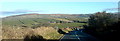
In the Preseli foothills
Mynydd Castlebythe is the furthest hill visible. The road that leads to Letterston veers off to the left in the distance.
Image: © Deborah Tilley
Taken: 14 Feb 2010
0.08 miles
2
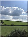
Farmland near Woodstock
There is a minor road cutting across and in the far distance is a VHF transmitter
Image: © Eirian Evans
Taken: 29 Aug 2022
0.21 miles
3
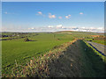
The Landsker near Bigws, Ambleston
The minor road that runs east-west across the picture is the "traditional" Landsker (the language boundary), as described by George Owen in the sixteenth century. By the end of the nineteenth century, the parish of Ambleston to the south had become almost exclusively Welsh-speaking, and this "re-cymricisation" may have been under way in George Owen's time. The road is actually the old "Roman" road towards St David's, and was the northern boundary of the hundred of Daugleddy, so it was more a de jure administrative boundary than a de facto cultural boundary. The real boundary has moved around, and was probably a good deal further north in the fourteenth century, when villages like Henry's Moat and New Moat were English plantations.
Image: © Dylan Moore
Taken: 23 Oct 2016
0.23 miles