IMAGES TAKEN NEAR TO
Wolfsdale, HAVERFORDWEST, SA62 6JH
Introduction
This page details the photographs taken nearby to SA62 6JH by members of the Geograph project.
The Geograph project started in 2005 with the aim of publishing, organising and preserving representative images for every square kilometre of Great Britain, Ireland and the Isle of Man.

There are currently over 7.5m images from over14,400 individuals and you can help contribute to the project by visiting https://www.geograph.org.uk
Image Map
Images are licensed for reuse under creativecommons.org/licenses/by-sa/2.0
Notes
- Clicking on the map will re-center to the selected point.
- The higher the marker number, the further away the image location is from the centre of the postcode.
Image Listing (10 Images Found)
Images are licensed for reuse under creativecommons.org/licenses/by-sa/2.0
Image
Details
Distance
1
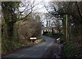
Wolfsdale bridge near Camrose
Small bridge over a stream which is nameless on the OS map. There is a sewage pumping station to the right of the bridge.
Image: © Natasha Ceridwen de Chroustchoff
Taken: 31 Dec 2009
0.06 miles
2
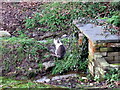
Wolfsdale cat
Not a living soul was to be seen in this isolated hamlet when I briefly stopped, except for this shy cat beside a stream.
Image: © Natasha Ceridwen de Chroustchoff
Taken: 31 Dec 2009
0.15 miles
3
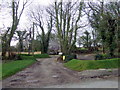
Winter in Wolfsdale
Farm on a road junction in Wolfsdale. The green turfed banks make a startling contrast with the leafless trees - almost like astroturf!
The name (sometimes referred to as Wolfdale, perhaps an earlier spelling) must be related to the village of Wolfscastle/Cas Blaidd nearby but in this case there appears to be no Welsh form.
Image: © Natasha Ceridwen de Chroustchoff
Taken: 31 Dec 2009
0.16 miles
5
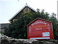
Wolfsdale United Reformed Church
Formerly Bethel Independent chapel, a sizeable building for this hamlet in the parish of Camrose.
Image: © Natasha Ceridwen de Chroustchoff
Taken: 31 Dec 2009
0.17 miles
6
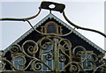
Bethel chapel dates
Built 1827, Renovated 1874, Rebuilt 1900.
The History of the Welsh Independent Churches/Hanes Eglwysi Annibynnol Cymru (1871) states that some people in this anglophone area of the Landsker were converted to noncomformism by preachers from Rhosycaerau around 1810 and the chapel was built in 1827 on land acquired from John Reynish, the local squire, on a 1000 year lease.
Nowadays the chapel is now part of the United Reformed Church.
Image: © Natasha Ceridwen de Chroustchoff
Taken: 31 Dec 2009
0.17 miles
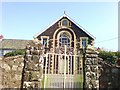
7
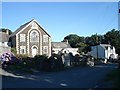
Bethel Chapel at Wolfsdale
Erected in 1927 as an independent congregational chapel, now part of the United Reformed Church
Image: © Simon Mortimer
Taken: 25 Jul 2007
0.17 miles
8
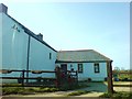
Wolfsdale Pit
Curious name for a dwelling. I couldn't see any evidence of mining.
Image: © Deborah Tilley
Taken: 22 Mar 2009
0.17 miles
9
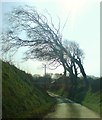
Lane to Upper House, Wolfsdale
The bent trees are a strong indicator of the prevailing winds, or maybe they've been cut that way to avoid the overhead cables.
Image: © Deborah Tilley
Taken: 22 Mar 2009
0.21 miles
10

Ordnance Survey Cut Mark
This OS cut mark can be found on the barn at Upper House Farm. It marks a point 70.384m above mean sea level.
Image: © Adrian Dust
Taken: 23 Apr 2017
0.22 miles