IMAGES TAKEN NEAR TO
Spittal, HAVERFORDWEST, SA62 5RF
Introduction
This page details the photographs taken nearby to SA62 5RF by members of the Geograph project.
The Geograph project started in 2005 with the aim of publishing, organising and preserving representative images for every square kilometre of Great Britain, Ireland and the Isle of Man.

There are currently over 7.5m images from over14,400 individuals and you can help contribute to the project by visiting https://www.geograph.org.uk
Image Map (Loading...)


Getting Data...Please wait
Leaflet Map data © OpenStreetMap
Images are licensed for reuse under creativecommons.org/licenses/by-sa/2.0
Notes
- Clicking on the map will re-center to the selected point.
- The higher the marker number, the further away the image location is from the centre of the postcode.
Image Listing (3 Images Found)
Images are licensed for reuse under creativecommons.org/licenses/by-sa/2.0
Image
Details
Distance
1
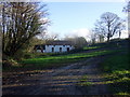
Barn conversion at Froghall
Froghall comprises a cluster of dwellings and farm buildings down a cul-de-sac near Spittal. This old barn has been nicely converted.
Image: © Natasha Ceridwen de Chroustchoff
Taken: 28 Nov 2007
0.11 miles
2
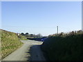
Approaching Froghall Cross
Approaching a crossroads with the B4329 from a country road near Spittal.
Image: © Martyn Harries
Taken: 4 Mar 2011
0.19 miles
3
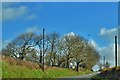
Road To Woodstock
Between Haverfordwest and Cardigan.
Image: © Deborah Tilley
Taken: 25 Mar 2016
0.21 miles