IMAGES TAKEN NEAR TO
Croesgoch, HAVERFORDWEST, SA62 5JT
Introduction
This page details the photographs taken nearby to SA62 5JT by members of the Geograph project.
The Geograph project started in 2005 with the aim of publishing, organising and preserving representative images for every square kilometre of Great Britain, Ireland and the Isle of Man.

There are currently over 7.5m images from over14,400 individuals and you can help contribute to the project by visiting https://www.geograph.org.uk
Image Map (28 Images)


Leaflet Map data © OpenStreetMap
Images are licensed for reuse under creativecommons.org/licenses/by-sa/2.0
Notes
- Clicking on the map will re-center to the selected point.
- The higher the marker number, the further away the image location is from the centre of the postcode.
Image Listing (28 Images Found)
Images are licensed for reuse under creativecommons.org/licenses/by-sa/2.0
Image
Details
Distance
1
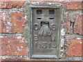
Ordnance Survey Flush Bracket 11514
This can be found on the wall of the Farm Stores building.
For more detail see : http://www.bench-marks.org.uk/bm22528
Image: © Peter Wood
Taken: 20 May 2013
0.08 miles
2
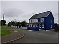
Blue and Grey at Croes-Goch, Pembrokeshire
Image: © Jeff Gogarty
Taken: 22 Sep 2020
0.09 miles
3
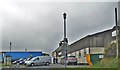
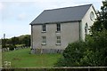
Croesgoch Farm Stores
A farmers' co-operative.
Image: © Deborah Tilley
Taken: 4 Feb 2016
0.09 miles
4
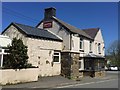
The Artramont Arms, Croes-goch
Village pub by a crossroads.
Artramont is a place near Wexford in Ireland.
There must be a connection between there and here, but a quick web search doesn't
show one.
Image: © Des Blenkinsopp
Taken: 7 Aug 2024
0.11 miles
5
The Atramont Arms
The Atramont Arms, Croesgoch.
Image: © Alan Hughes
Taken: 18 May 2016
0.11 miles
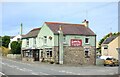
6
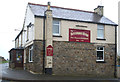
Artramont Arms, Croes-goch
This public house took its name from the Le Hunte family's estate in Artramont, County Wexford, Ireland. It dates from the late 19th C and has served the community in various guises over the years.
Image: © Stuart Logan
Taken: 5 Oct 2011
0.11 miles
7
The Artramont Arms
The Artramont Arms, established 1795 ,Croesgoch, St Davids, Pembrokeshire
Image: © Arthur C Harris
Taken: 18 Oct 2013
0.11 miles
8
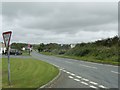
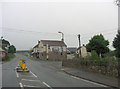
The A487 through Croes-Goch
Taken from the junction by the A487. The car in the distance is turning into the B4330 Croes-Goch to Haverfordwest road.
Image: © Martyn Harries
Taken: 21 Sep 2009
0.12 miles
9
Croesgoch Baptist Chapel
The chapel was built in 1816. Viewed here from the west, from the top of the road to Llanrhian. Recent felling of conifers has given the view of the cleared burial ground. Just visible on the lower left of the picture are the railings around the outdoor baptistery.
Image: © Simon Mortimer
Taken: 23 Aug 2017
0.13 miles
10
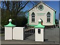
Croesgoch
Capel y Bedyddwyr, Croesgoch.
Image: © Alan Hughes
Taken: 18 May 2016
0.13 miles