IMAGES TAKEN NEAR TO
The Haggard, HAVERFORDWEST, SA62 5HQ
Introduction
This page details the photographs taken nearby to The Haggard, SA62 5HQ by members of the Geograph project.
The Geograph project started in 2005 with the aim of publishing, organising and preserving representative images for every square kilometre of Great Britain, Ireland and the Isle of Man.

There are currently over 7.5m images from over14,400 individuals and you can help contribute to the project by visiting https://www.geograph.org.uk
Image Map
Images are licensed for reuse under creativecommons.org/licenses/by-sa/2.0
Notes
- Clicking on the map will re-center to the selected point.
- The higher the marker number, the further away the image location is from the centre of the postcode.
Image Listing (76 Images Found)
Images are licensed for reuse under creativecommons.org/licenses/by-sa/2.0
Image
Details
Distance
1
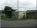
Public convenience and bus shelter, Mathry
Located at the top of Mathry Hill by the small car parking area.
Image: © Martyn Harries
Taken: 21 Sep 2009
0.01 miles
2
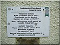
Small notice on the wall, Mathry
The notice is screwed onto the wall of the public conveniences at Mathry. These conveniences are open mainly during the Spring and Summer months. However, in Winter, the nearest alternative public convenience is five miles away (approx) at Letterston Square, opposite the Something's Cooking restaurant by the A40. There is even a map below the notice to assist members of the public to locate the alternative facility at Letterston Square.
Image: © Martyn Harries
Taken: 21 Sep 2009
0.01 miles
3
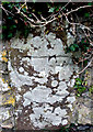
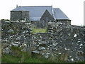
Wheel Cross Mathry Church
One of two wheel crosses in the boundary wall of Mathry Church
Image: © Anonymous
Taken: 8 Oct 2006
0.02 miles
4
Step through stile, Mathry
The stile, provides an alternative route into the churchyard and allows the walker to step through the gap in the stone wall.
Image: © Martyn Harries
Taken: 11 Jul 2010
0.02 miles
5
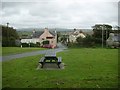
Mathry village green
Four roads and several tracks meet here at this hilltop village which was once important enough to have a weekly market and an annual hiring fair. Community events still take place on the green. This is the view looking up from beside the pub, the church is immediately to the right with the shop above and the school below it.
Image: © Natasha Ceridwen de Chroustchoff
Taken: 4 Jan 2007
0.02 miles
6
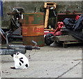
Farm cat
Quite at home among the agricultural machinery in this farmyard in Mathry village.
Image: © Natasha Ceridwen de Chroustchoff
Taken: 4 Jan 2007
0.02 miles
7
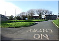
One-way traffic system, Mathry
Viewed from the top of Mathry Hill. There is no entry for traffic to travel downhill from the top of the hill past the Farmers Arms pub. The road junction near the pub and below the village green has road signs to remind drivers of the one-way system. Traffic can only travel uphill, one way, from the Farmers Arms pub to the top of the hill. In the distance, between the two no entry signs, is the B4331 road.
Image: © Martyn Harries
Taken: 21 Sep 2009
0.02 miles
8
Ancient Stone Mathry Church
Ancient stone situated in the porch of Mathry Church
Image: © Anonymous
Taken: 8 Oct 2006
0.03 miles
9
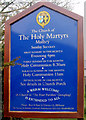
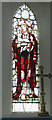
Mathry Church Noticeboard
Times of services at The Church of The Holy Martyrs, Mathry
Image: © Anonymous
Taken: 8 Oct 2006
0.03 miles