IMAGES TAKEN NEAR TO
Brynhedydd, HAVERFORDWEST, SA62 5EX
Introduction
This page details the photographs taken nearby to Brynhedydd, SA62 5EX by members of the Geograph project.
The Geograph project started in 2005 with the aim of publishing, organising and preserving representative images for every square kilometre of Great Britain, Ireland and the Isle of Man.

There are currently over 7.5m images from over14,400 individuals and you can help contribute to the project by visiting https://www.geograph.org.uk
Image Map (Loading...)


Getting Data...Please wait
Leaflet Map data © OpenStreetMap
Images are licensed for reuse under creativecommons.org/licenses/by-sa/2.0
Notes
- Clicking on the map will re-center to the selected point.
- The higher the marker number, the further away the image location is from the centre of the postcode.
Image Listing (72 Images Found)
Images are licensed for reuse under creativecommons.org/licenses/by-sa/2.0
Image
Details
Distance
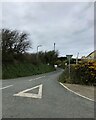
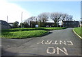
2
Bus stop and houses at a crossroads near Mathry
Image: © Rob Purvis
Taken: 2 Jun 2022
0.07 miles
4
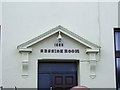
Former Magistrates Court, Mathry
A close-up of the entrance to the former magistrates court built in 1909. Mathry, for many years, from the 19th century till the 1970s, had its own magistrates court. It is now a diving school, but the 'SESSION ROOM' name still remains.
Image: © Martyn Harries
Taken: 2 Apr 2010
0.10 miles
5
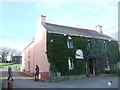
The Farmers' Arms, Mathry
On entering the village up the hill from the southeast, off the A487, you meet the pub face on. It is positioned just below the village green, seen here to the left, and from this viewpoint completely obscures the church which stands behind it. The Farmers' Arm is a popular resort for both locals and holidaymakers.
Image: © Natasha Ceridwen de Chroustchoff
Taken: 4 Jan 2007
0.11 miles
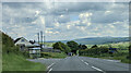
6
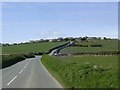
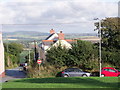
Mathry Hill from the B4331 road
The B4331 road connects the A40 at Letterston and the A487 at the bottom of the hill. The village of Mathry is at the top of the hill.
Image: © Martyn Harries
Taken: 24 Mar 2009
0.12 miles
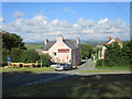
7
Mathry village green
Four roads and several tracks meet here at this hilltop village which was once important enough to have a weekly market and an annual hiring fair. Community events still take place on the green. This is the view looking up from beside the pub, the church is immediately to the right with the shop above and the school below it.
Image: © Natasha Ceridwen de Chroustchoff
Taken: 4 Jan 2007
0.12 miles
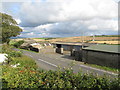
8
Mathry Hill
Mathry sits on top of a small hill sufficient to give wide views, as here, of the Preseli Hills.
Image: © Jonathan Thacker
Taken: 2 Jul 2015
0.13 miles
10
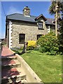
House at Mathry
Well tended garden at house in Mathry.
Image: © Alan Hughes
Taken: 16 May 2016
0.13 miles