IMAGES TAKEN NEAR TO
Puncheston, HAVERFORDWEST, SA62 5DL
Introduction
This page details the photographs taken nearby to SA62 5DL by members of the Geograph project.
The Geograph project started in 2005 with the aim of publishing, organising and preserving representative images for every square kilometre of Great Britain, Ireland and the Isle of Man.

There are currently over 7.5m images from over14,400 individuals and you can help contribute to the project by visiting https://www.geograph.org.uk
Image Map
Images are licensed for reuse under creativecommons.org/licenses/by-sa/2.0
Notes
- Clicking on the map will re-center to the selected point.
- The higher the marker number, the further away the image location is from the centre of the postcode.
Image Listing (6 Images Found)
Images are licensed for reuse under creativecommons.org/licenses/by-sa/2.0
Image
Details
Distance
1
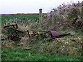
Old plough near Puncheston
Left by a hedgebank - since when?
Image: © Natasha Ceridwen de Chroustchoff
Taken: 6 Jan 2008
0.09 miles
2
Farm entrance
Entrance to Upper Wern Farm.
Image: © Alan Hughes
Taken: 21 Apr 2021
0.12 miles
3
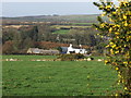
Upper Wern Farm
Typical livestock farm in this area.
Image: © John Haynes
Taken: 2 Dec 2007
0.15 miles
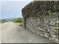
4
Ordnance Survey Cut Mark
This OS cut mark can be found on a gatepost north side of the road. It marks a point 167.719m above mean sea level.
Image: © Adrian Dust
Taken: 27 Feb 2017
0.22 miles
5
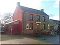
The Drovers Arms
A long established public house.
Image: © Deborah Tilley
Taken: 5 Dec 2008
0.25 miles
6
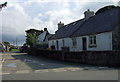
Road junction, Casmael/Puncheston
This is a nucleated village positioned at the crossing of ways and once close to the railway line that ran through the Anghof valley. It is said that the Normans who established themselves here forced the natives to abandon their scattered dwellings and move into a settlement where they could be more effectively controlled.
There remain quite a number of this simple, single-storey cottages that would perhaps have once been thatched.
Image: © Natasha Ceridwen de Chroustchoff
Taken: 4 Sep 2008
0.25 miles