IMAGES TAKEN NEAR TO
Llangwm, HAVERFORDWEST, SA62 4HN
Introduction
This page details the photographs taken nearby to SA62 4HN by members of the Geograph project.
The Geograph project started in 2005 with the aim of publishing, organising and preserving representative images for every square kilometre of Great Britain, Ireland and the Isle of Man.

There are currently over 7.5m images from over14,400 individuals and you can help contribute to the project by visiting https://www.geograph.org.uk
Image Map (Loading...)


Getting Data...Please wait
Leaflet Map data © OpenStreetMap
Images are licensed for reuse under creativecommons.org/licenses/by-sa/2.0
Notes
- Clicking on the map will re-center to the selected point.
- The higher the marker number, the further away the image location is from the centre of the postcode.
Image Listing (14 Images Found)
Images are licensed for reuse under creativecommons.org/licenses/by-sa/2.0
Image
Details
Distance
1
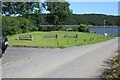
Picnic site, Black Tar
Pleasant, well maintained site at the end of the highway with good views over the Daugleddau. Sam's Wood is on the skyline.
Image: © M J Roscoe
Taken: 11 Aug 2024
0.07 miles
2
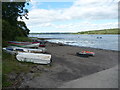
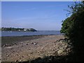
Slipway and foreshore at Blacktar Point
The waters of the Daugleddau lap against mudflats and the slipway here. A spot where you simply must soak up all the sights, sounds and scents.
Image: © Jeremy Bolwell
Taken: 9 Aug 2011
0.08 miles
3
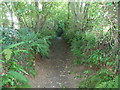
Sunken way near Blacktar Point
Probably a very old route between Llangwm village and the point.
Image: © Jeremy Bolwell
Taken: 9 Aug 2011
0.10 miles
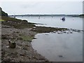
4
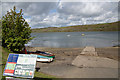
Black Tar Point
Black Tar Point, Llangwm, a spot where black tar was applied to fishing boats in times past to keep them water tight.
Image: © Arthur C Harris
Taken: 29 Apr 2015
0.11 miles
5
Black Tar
Black Tar taken from the opposite bank of the Cleddau, at Coedcanlas.
Image: © Shaun Butler
Taken: 14 Sep 2003
0.12 miles
7
Upriver view
Looking to Blacktar Point.
Image: © Deborah Tilley
Taken: 10 Apr 2011
0.20 miles
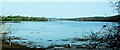
8
Western Cleddau
Looking north along the river towards Haverfordwest from Blacktar Point.
Image: © Garth Newton
Taken: 22 Jul 2004
0.20 miles
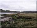
9
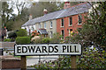
Edwards Pill, Llangwm
Edwards Pill, Llangwm, on the tidal Cleddau.
Image: © Arthur C Harris
Taken: 27 Apr 2015
0.21 miles
10
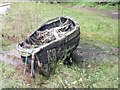
The old K8 at Edwards Pill
Old fishing boat used for compass net fishing on the Cleddau.
Image: © Shaun Butler
Taken: 7 Aug 2008
0.21 miles