IMAGES TAKEN NEAR TO
Crundale, HAVERFORDWEST, SA62 4DY
Introduction
This page details the photographs taken nearby to SA62 4DY by members of the Geograph project.
The Geograph project started in 2005 with the aim of publishing, organising and preserving representative images for every square kilometre of Great Britain, Ireland and the Isle of Man.

There are currently over 7.5m images from over14,400 individuals and you can help contribute to the project by visiting https://www.geograph.org.uk
Image Map (Loading...)


Getting Data...Please wait
Leaflet Map data © OpenStreetMap
Images are licensed for reuse under creativecommons.org/licenses/by-sa/2.0
Notes
- Clicking on the map will re-center to the selected point.
- The higher the marker number, the further away the image location is from the centre of the postcode.
Image Listing (2 Images Found)
Images are licensed for reuse under creativecommons.org/licenses/by-sa/2.0
Image
Details
Distance
1
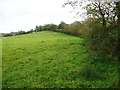
Footpath to The Rath, Rudbaxton
There is no signpost, but the map shows a public footpath going up to the entrance to the hillfort. There is just room to park a small car on the verge next to the gate.
Image: © Humphrey Bolton
Taken: 27 Oct 2016
0.16 miles
2
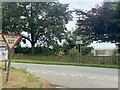
Approaching the B4329 near Poyston Cross
Image: © Alan Hughes
Taken: 4 Aug 2024
0.25 miles