IMAGES TAKEN NEAR TO
Dreenhill, HAVERFORDWEST, SA62 3TS
Introduction
This page details the photographs taken nearby to SA62 3TS by members of the Geograph project.
The Geograph project started in 2005 with the aim of publishing, organising and preserving representative images for every square kilometre of Great Britain, Ireland and the Isle of Man.

There are currently over 7.5m images from over14,400 individuals and you can help contribute to the project by visiting https://www.geograph.org.uk
Image Map
Images are licensed for reuse under creativecommons.org/licenses/by-sa/2.0
Notes
- Clicking on the map will re-center to the selected point.
- The higher the marker number, the further away the image location is from the centre of the postcode.
Image Listing (4 Images Found)
Images are licensed for reuse under creativecommons.org/licenses/by-sa/2.0
Image
Details
Distance
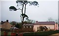
1
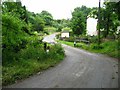
Denant Mill
Bridge over Merlins Brook at Denant Mill. Mill is now a Private residence, out of sight left of picture.
Image: © Shaun Butler
Taken: 24 Jun 2008
0.01 miles
2
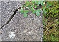
Ordnance Survey Rivet
This OS rivet can be found on the milk stand at Denant Mill. It marks a point 27.174m above mean sea level.
Image: © Adrian Dust
Taken: 16 Apr 2017
0.01 miles
3
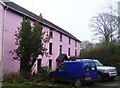
Denant Mill
Denant Mill was built in 1592 and operated as a grain mill until the 1950s. The property was purchased by the local authority in the 60s as the valley was to be flooded for a reservoir. This never happened and the property was developed as a restaurant and guest house in the 1990's. Now a private dwelling.
Image: © Deborah Tilley
Taken: 20 Feb 2011
0.05 miles