IMAGES TAKEN NEAR TO
HAVERFORDWEST, SA62 3SD
Introduction
This page details the photographs taken nearby to SA62 3SD by members of the Geograph project.
The Geograph project started in 2005 with the aim of publishing, organising and preserving representative images for every square kilometre of Great Britain, Ireland and the Isle of Man.

There are currently over 7.5m images from over14,400 individuals and you can help contribute to the project by visiting https://www.geograph.org.uk
Image Map
Images are licensed for reuse under creativecommons.org/licenses/by-sa/2.0
Notes
- Clicking on the map will re-center to the selected point.
- The higher the marker number, the further away the image location is from the centre of the postcode.
Image Listing (2 Images Found)
Images are licensed for reuse under creativecommons.org/licenses/by-sa/2.0
Image
Details
Distance
1
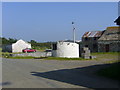
Lower Solbury
The only building in a decent state is the curious circular building with a sloping roof.
Image: © Roger W Haworth
Taken: 8 Jun 2007
0.04 miles
2
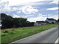
The White Hart, disused pub at Upper Solbury, Pembs
Image: © nick macneill
Taken: 9 Sep 2010
0.24 miles