IMAGES TAKEN NEAR TO
Orchard Court, HAVERFORDWEST, SA62 3PZ
Introduction
This page details the photographs taken nearby to Orchard Court, SA62 3PZ by members of the Geograph project.
The Geograph project started in 2005 with the aim of publishing, organising and preserving representative images for every square kilometre of Great Britain, Ireland and the Isle of Man.

There are currently over 7.5m images from over14,400 individuals and you can help contribute to the project by visiting https://www.geograph.org.uk
Image Map (Loading...)


Getting Data...Please wait
Leaflet Map data © OpenStreetMap
Images are licensed for reuse under creativecommons.org/licenses/by-sa/2.0
Notes
- Clicking on the map will re-center to the selected point.
- The higher the marker number, the further away the image location is from the centre of the postcode.
Image Listing (163 Images Found)
Images are licensed for reuse under creativecommons.org/licenses/by-sa/2.0
Image
Details
Distance
1
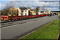
Orchard Court, Johnston
Modern housing on the west side of the A4076 St Peter's Road.
Image: © Jaggery
Taken: 18 Feb 2016
0.01 miles
2
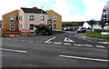
Towards Acorn Drive, Johnston
Viewed across the A4076 St Peter's Road. The sign on the right shows
ORCHARD COURT LEADING TO ACORN DRIVE.
Image: © Jaggery
Taken: 18 Feb 2016
0.02 miles
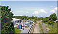
3
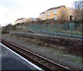
Disused platform at Johnston railway station
In February 2016, I was amused to hear a recorded message begin "The next train to arrive at Platform 1..." because there is only one platform now, alongside the West Wales Line at Johnston railway station, used by trains in both directions.
In 1988, the West Wales Line south of Clarbeston Road station was reduced from double track to single track.
The platform at Johnston for southbound trains was thereby taken out of use.
Image: © Jaggery
Taken: 18 Feb 2016
0.02 miles
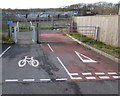
4
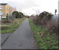
National Cycle Network route 4 from Johnston towards Neyland
The route is here parallel with the West Wales Line railway near Johnston station.
A nearby signpost shows ahead for Neyland (4 miles), behind the camera for Haverfordwest (5).
Image: © Jaggery
Taken: 18 Feb 2016
0.02 miles
5
Johnston (Dyfed) Station
View northward, towards Haverfordwest, Clarbeston Road and Whitland; ex-GWR (Swansea etc.) - Whitland - Milford Haven line, junction of branch to Neyland until 15/6/64.
Image: © Ben Brooksbank
Taken: 24 Jun 2004
0.03 miles
6
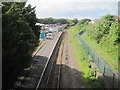
Johnston railway station, Pembrokeshire
Opened in 1856 by the South Wales Railway on its line from Carmarthen to Neyland.
View north west towards Haverfordwest and Carmarthen. The disused former southbound platform can be seen on the right.
Image: © Nigel Thompson
Taken: 6 Jun 2017
0.03 miles
7
Cyclists Rejoin Road sign, Johnston
The bilingual (Welsh/English) sign faces these barriers http://www.geograph.org.uk/photo/5008842 and National Cycle Network route 4.
The A4076, the main road through Johnston, is 70 metres ahead.
Image: © Jaggery
Taken: 18 Feb 2016
0.03 miles
8
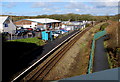
Johnston railway station from St Peter's Road bridge
Johnston is an unstaffed single-platform request-stop station on the West Wales Line between the line's terminus
at Milford Haven station, and Haverfordwest station (ahead). Part of Johnston Business Park is on the left.
A combined footpath and cycle route is on the right, part of National Cycle Network Route 4.
Image: © Jaggery
Taken: 18 Feb 2016
0.03 miles
9
This way to National Cycle Network route 4, Johnston
Ahead is National Cycle Network route 4, here parallel with the West Wales Line railway.
A nearby cycle network signpost shows 5 (miles) to Haverfordwest, 4 to Neyland.
Image: © Jaggery
Taken: 18 Feb 2016
0.04 miles
10
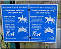
National Cycle Network bilingual information, Johnston
The English/Welsh information is on the post on the left here. http://www.geograph.org.uk/photo/5008842
Image: © Jaggery
Taken: 18 Feb 2016
0.04 miles