IMAGES TAKEN NEAR TO
Millmoor Way, HAVERFORDWEST, SA62 3JJ
Introduction
This page details the photographs taken nearby to Millmoor Way, SA62 3JJ by members of the Geograph project.
The Geograph project started in 2005 with the aim of publishing, organising and preserving representative images for every square kilometre of Great Britain, Ireland and the Isle of Man.

There are currently over 7.5m images from over14,400 individuals and you can help contribute to the project by visiting https://www.geograph.org.uk
Image Map (Loading...)


Getting Data...Please wait
Leaflet Map data © OpenStreetMap
Images are licensed for reuse under creativecommons.org/licenses/by-sa/2.0
Notes
- Clicking on the map will re-center to the selected point.
- The higher the marker number, the further away the image location is from the centre of the postcode.
Image Listing (58 Images Found)
Images are licensed for reuse under creativecommons.org/licenses/by-sa/2.0
Image
Details
Distance
1

Sunset at Millmoor Way Car Park, Broad Haven
Image: © Simon Mortimer
Taken: 19 Sep 2024
0.05 miles
2
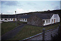
Broad Haven Youth Hostel
Broad Haven Youth Hostel pictured in March 1987 when I was walking the Pembrokeshire Coast Path.
Image: © Philip Halling
Taken: 23 Mar 1987
0.08 miles
4
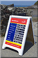
RNLI Lifeguards information board - Broad Haven
The beach lifeguards service is run by the RNLI and on this July day Meg, Daf and Jon were on duty. There is a wealth of useful information neatly filled in but the bit to gladden the heart of any holidaymaker is near the bottom - 'Conditions - glorious sunshine'.
Image: © Stephen McKay
Taken: 16 Jul 2019
0.11 miles
5
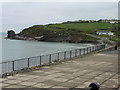
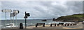
The Pembrokeshire Coast Path at Broad Haven
Image: © Dave Kelly
Taken: 12 May 2017
0.11 miles
6
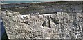
Ordnance Survey Cut Mark
This OS cut mark can be found on the gatepost at the entrance to Haroldston Hall. It marks a point 9.867m above mean sea level.
Image: © Adrian Dust
Taken: 23 Apr 2017
0.11 miles
7
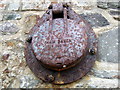
Ham baker!
The seawall is studded with these rusty objects which I assume to be drainage outflows, but it's tempting to see the words as representing their function rather than their manufacturer: a chilly day on the sands, fresh baked ham, mmm...
Image: © Natasha Ceridwen de Chroustchoff
Taken: 6 May 2007
0.12 miles
9
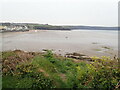
Low tide on Broad Haven beach
A huge expanse of firm sand at low tide, but at high tide there is just a long narrow pebble beach.
Image: © Eirian Evans
Taken: 30 Apr 2022
0.12 miles
10
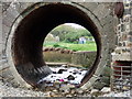
Pipework
The stream that meets the sea at Broad Haven has been channelled as it runs under the beach road at this point. The water level is very low.
Behind is the area known as Mill Moor, and a caravan holiday camp.
Image: © Natasha Ceridwen de Chroustchoff
Taken: 6 May 2007
0.12 miles