1
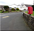
Springfield Close, Haverfordwest
On the west side of Cardigan Road.
Image: © Jaggery
Taken: 11 Mar 2019
0.01 miles
2
Queen Elizabeth II postbox on top of a Haverfordwest wall
On the wall on the corner of Cardigan Road and Lindsway Park.
Image: © Jaggery
Taken: 11 Mar 2019
0.05 miles
3
Cardigan Road, Haverfordwest
Image: © Peter Whatley
Taken: 23 Jul 2009
0.06 miles
4
Dead-end part of Cardigan Road, Haverfordwest
Shown on maps as Cardigan Road, the cul-de-sac ahead is on the west side of the B4329 Cardigan Road.
Image: © Jaggery
Taken: 11 Mar 2019
0.06 miles
5
Cardigan Road houses, Haverfordwest
Houses on the east side of the B4329 Cardigan Road between the Greenfield Close junction and the Springfield Close junction.
Image: © Jaggery
Taken: 11 Mar 2019
0.06 miles
6
'Looking Up' at Withybush Hospital
Stone head by local artist John Cleal who died in 2007. The sculpture symbolizes optimism and faith in the future and was donated by the artist in recognition of the help received by him and his family from the hospital over the years.
Image: © Natasha Ceridwen de Chroustchoff
Taken: 14 Aug 2008
0.06 miles
7
Sundown on the Cardigan Road
Starkly silhouetted trees stand out against the dusky sky.
Image: © Deborah Tilley
Taken: 5 Mar 2009
0.09 miles
8
Withybush Hospital
The new undercover drop off point.
Image: © Deborah Tilley
Taken: 21 Aug 2008
0.10 miles
9
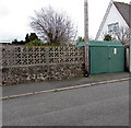
Greenfield Close electricity substation, Haverfordwest
The green cabinet is a Western Power Distribution electricity substation.
Its identifier is GREENFIELDS CARDIGAN RD S/S 60-6006.
Image: © Jaggery
Taken: 11 Mar 2019
0.10 miles
10
"Desire path" into Withybush retail park (2)
For as long as I have been coming to this small out-of-town shopping centre, when on foot I have made use of this unofficial way in that leads through a gap in the fence and down a bank into the car park. The only alternative for pedestrians is to use the pavement that follows the vehicular access road, clearly judged by many to be an unnecessary detour.
These short cuts that ignore planned routes are known as 'desire paths' as they constitute the shortest way to where one wants to go and they may cross landscaped features such a lawns and flowerbeds. Sometimes planners wait until walkers or cyclists have chosen their optimal routes before creating formal versions. Attempts to block the use of desire-paths is usually unsuccessful although in this case mending the fence might stop all but the most determined. See https://en.wikipedia.org/wiki/Desire_path and http://99percentinvisible.org/article/least-resistance-desire-paths-can-lead-better-design/
Image: © Natasha Ceridwen de Chroustchoff
Taken: 29 Mar 2017
0.10 miles


