IMAGES TAKEN NEAR TO
Old Hakin Road, HAVERFORDWEST, SA61 1XG
Introduction
This page details the photographs taken nearby to Old Hakin Road, SA61 1XG by members of the Geograph project.
The Geograph project started in 2005 with the aim of publishing, organising and preserving representative images for every square kilometre of Great Britain, Ireland and the Isle of Man.

There are currently over 7.5m images from over14,400 individuals and you can help contribute to the project by visiting https://www.geograph.org.uk
Image Map
Images are licensed for reuse under creativecommons.org/licenses/by-sa/2.0
Notes
- Clicking on the map will re-center to the selected point.
- The higher the marker number, the further away the image location is from the centre of the postcode.
Image Listing (4 Images Found)
Images are licensed for reuse under creativecommons.org/licenses/by-sa/2.0
Image
Details
Distance
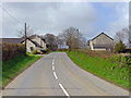
1
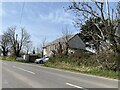
House opposite Ash Grove Farm
Minor road from Haverfordwest to Tiers Cross.
Image: © Alan Hughes
Taken: 19 Apr 2021
0.01 miles
3
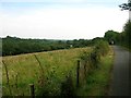
National Cycle Network Route 4 near Haverfordwest
Looking west along the valley of Merlin's Brook towards Haverfordwest. The cycle path runs parallel to the Haverfordwest to Milford Haven railway on this section.
Image: © Simon Mortimer
Taken: 11 Aug 2012
0.17 miles
4
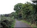
Llwybr Beicio / Cycle Path
Llwybr beicio yn mynd i gyfeiriad Hwlffordd.
A cycle path heading in the direction of Haverfordwest.
Image: © Alan Richards
Taken: 7 Sep 2016
0.23 miles