IMAGES TAKEN NEAR TO
HAVERFORDWEST, SA61 1WR
Introduction
This page details the photographs taken nearby to SA61 1WR by members of the Geograph project.
The Geograph project started in 2005 with the aim of publishing, organising and preserving representative images for every square kilometre of Great Britain, Ireland and the Isle of Man.

There are currently over 7.5m images from over14,400 individuals and you can help contribute to the project by visiting https://www.geograph.org.uk
Image Map (Loading...)


Getting Data...Please wait
Leaflet Map data © OpenStreetMap
Images are licensed for reuse under creativecommons.org/licenses/by-sa/2.0
Notes
- Clicking on the map will re-center to the selected point.
- The higher the marker number, the further away the image location is from the centre of the postcode.
Image Listing (26 Images Found)
Images are licensed for reuse under creativecommons.org/licenses/by-sa/2.0
Image
Details
Distance
1
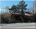
Partly hidden Haverfordwest Delivery Office
Vegetation obscures the east (Merlins Hill) side of the Royal Mail premises in Merlins Bridge.
Image: © Jaggery
Taken: 18 Apr 2014
0.01 miles
2
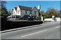
The Glen, Haverfordwest
Pub and restaurant set back from the west side of the A487 Merlin's Hill.
Image: © Jaggery
Taken: 18 Apr 2014
0.05 miles
3
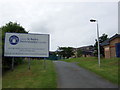
Coleg Sir Benfro/Pembrokeshire College
Haverfordwest's seat of higher learning.
Image: © Natasha Ceridwen de Chroustchoff
Taken: 4 Aug 2008
0.07 miles
4
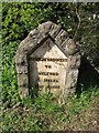
Old Milestone by the A4076, Merlin's Bridge Parish
Haverfordwest plate by the A4076, in parish of Merlin's Bridge (Pembrokeshire District), Merlin's Bridge, South of bridge over Merlin's Brook, West side of road.
Inscription reads:-
HAVERFORDWEST
TO
MILFORD
5 MILES
1515 YARDS
Grade II listed by Cadw. Reference Number: 82635
https://cadwpublic-api.azurewebsites.net/reports/listedbuilding/FullReport?lang=&id=82635
Surveyed
Milestone Society National ID: PEM_HWMF00
Image: © Milestone Society
Taken: Unknown
0.08 miles
5
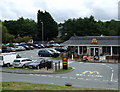
Fast food in Caradog's Well Road
McDonald's can't even manage a CROESO in its eagerness to suck in the students at this cunningly-located joint over the road from Pembrokeshire college.
Image: © Natasha Ceridwen de Chroustchoff
Taken: 4 Aug 2008
0.09 miles
6
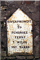
Old Milestone by Pembroke Road, Merlins Bridge, Haverfordwest
Haverfordwest plate by Pembroke Road, South of the A4076 roundabout, in parish of Merlin's Bridge (Pembrokeshire District), Merlins Bridge, 20m South of Merlins Bridge Post Office, Pembroke Road, inset into wall, East side of road.
Inscription reads:-
HAVERFORDWEST
TO
PEMBROKE
FERRY
7 MILES
237 YARDS
Grade II listed by Cadw.
Reference Number: 82634 https://cadwpublic-api.azurewebsites.net/reports/listedbuilding/FullReport?lang=&id=82634
Surveyed
Milestone Society National ID: PEM_HWPF00
Image: © Milestone Society
Taken: Unknown
0.11 miles
7
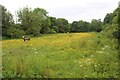
Meadow above Merlin's Brook
A field with buttercups next to Caradog's Well Road, right.
Image: © M J Roscoe
Taken: 23 May 2024
0.11 miles
8
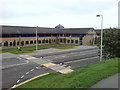
Pembrokeshire College
A well designed modern building with a nice atmosphere.
Image: © Deborah Tilley
Taken: 28 Aug 2008
0.11 miles
9
Grooming for pets and people, Magdalene Street
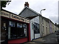
Tempting to speculate that Cutting Edge and Top Dog might be one and the same business behind the scenes!
Otherwise a residential street in the Merlin's Bridge area south of Haverfordwest, below Merlin's Brook.
Image: © Natasha Ceridwen de Chroustchoff
Taken: 4 Aug 2008
0.12 miles
10
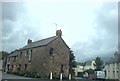
Magdalene Street, Merlin's Bridge
The name 'Merlin's Bridge' derived from the name Magdalene (pronounced Maudlin) not from the eponymous wizard!
Image: © Deborah Tilley
Taken: 17 Aug 2008
0.12 miles