Old Milestone by Pembroke Road, Merlins Bridge, Haverfordwest
Introduction
The photograph on this page of Old Milestone by Pembroke Road, Merlins Bridge, Haverfordwest by Milestone Society as part of the Geograph project.
The Geograph project started in 2005 with the aim of publishing, organising and preserving representative images for every square kilometre of Great Britain, Ireland and the Isle of Man.

There are currently over 7.5m images from over 14,400 individuals and you can help contribute to the project by visiting https://www.geograph.org.uk
Old Milestone by Pembroke Road, Merlins Bridge, Haverfordwest
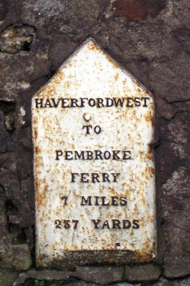
Image: © Milestone Society Taken: Unknown
Haverfordwest plate by Pembroke Road, South of the A4076 roundabout, in parish of Merlin's Bridge (Pembrokeshire District), Merlins Bridge, 20m South of Merlins Bridge Post Office, Pembroke Road, inset into wall, East side of road. Inscription reads:- HAVERFORDWEST TO PEMBROKE FERRY 7 MILES 237 YARDS Grade II listed by Cadw. Reference Number: 82634 https://cadwpublic-api.azurewebsites.net/reports/listedbuilding/FullReport?lang=&id=82634 Surveyed Milestone Society National ID: PEM_HWPF00
Images are licensed for reuse under creativecommons.org/licenses/by-sa/2.0
Image Location
Latitude
51.791385
Longitude
-4.977407