IMAGES TAKEN NEAR TO
Dew Street, HAVERFORDWEST, SA61 1SY
Introduction
This page details the photographs taken nearby to Dew Street, SA61 1SY by members of the Geograph project.
The Geograph project started in 2005 with the aim of publishing, organising and preserving representative images for every square kilometre of Great Britain, Ireland and the Isle of Man.

There are currently over 7.5m images from over14,400 individuals and you can help contribute to the project by visiting https://www.geograph.org.uk
Image Map
Images are licensed for reuse under creativecommons.org/licenses/by-sa/2.0
Notes
- Clicking on the map will re-center to the selected point.
- The higher the marker number, the further away the image location is from the centre of the postcode.
Image Listing (382 Images Found)
Images are licensed for reuse under creativecommons.org/licenses/by-sa/2.0
Image
Details
Distance
1
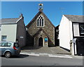
The Catholic Church of St David & St Patrick, Haverfordwest
The Dew Street church is part of the Roman Catholic Diocese of Menevia.
Image: © Jaggery
Taken: 18 Apr 2014
0.02 miles
2
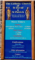
Nameboard of The Catholic Church of St David & St Patrick, Haverfordwest
Located here. http://www.geograph.org.uk/photo/4036819
Image: © Jaggery
Taken: 18 Apr 2014
0.02 miles
3
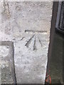
Ordnance Survey Cut Mark
This OS cut mark can be found on the Roman Catholic Church, Dew Street. It marks a point 43.830m above mean sea level.
Image: © Adrian Dust
Taken: 22 Aug 2015
0.02 miles
4
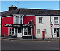
Dew Street Post Office, Haverfordwest
83 Dew Street, near the corner of Albert Street.
Image: © Jaggery
Taken: 18 Apr 2014
0.02 miles
5
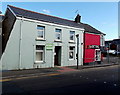
Laroc, Haverfordwest
Hairdressing, tanning and nail care salon at 85 Dew Street, on the corner of Albert Street.
Image: © Jaggery
Taken: 18 Apr 2014
0.02 miles
6
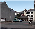
Samaritans, Haverfordwest
Located at 1 Albert Street, on the corner of Dew Street.
Image: © Jaggery
Taken: 18 Apr 2014
0.03 miles
7
Marychurch Court, Haverfordwest
Flats set back from Albert Street.
Image: © Jaggery
Taken: 18 Apr 2014
0.03 miles
8
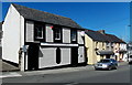
Haverfordwest Labour Club
Viewed across Dew Street.
Image: © Jaggery
Taken: 18 Apr 2014
0.03 miles
9
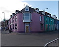
Corner of Milford Road and Albert Street, Haverfordwest
On the left (Milford Road) side of the purple building, the nameboard shows TAJ MAHAL (Indian cuisine restaurant and takeaway). This corner is part of a zigzag route for the A487, from Milford Road, along Albert Street then Barn Street, avoiding Dew Street and the town centre.
Image: © Jaggery
Taken: 18 Apr 2014
0.04 miles
10
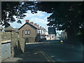
Albert Street
Named after the consort no doubt. A dilapidated old cemetery lies hidden on the right in the shadow of the awful Tesco not-so-superstore.
Image: © Deborah Tilley
Taken: 20 Jul 2008
0.04 miles