IMAGES TAKEN NEAR TO
Merlins Terrace, HAVERFORDWEST, SA61 1PH
Introduction
This page details the photographs taken nearby to Merlins Terrace, SA61 1PH by members of the Geograph project.
The Geograph project started in 2005 with the aim of publishing, organising and preserving representative images for every square kilometre of Great Britain, Ireland and the Isle of Man.

There are currently over 7.5m images from over14,400 individuals and you can help contribute to the project by visiting https://www.geograph.org.uk
Image Map
Images are licensed for reuse under creativecommons.org/licenses/by-sa/2.0
Notes
- Clicking on the map will re-center to the selected point.
- The higher the marker number, the further away the image location is from the centre of the postcode.
Image Listing (58 Images Found)
Images are licensed for reuse under creativecommons.org/licenses/by-sa/2.0
Image
Details
Distance
1
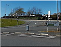
7 miles from Haverfordwest to Milford Haven
The signs points left (SW) down the A487 Merlin's Hill towards the A4076.
Image: © Jaggery
Taken: 18 Apr 2014
0.02 miles
2
Mary Immaculate Catholic School in Haverfordwest
Built in 2007, the Catholic primary school is at the top of Merlin's Hill.
Image: © Jaggery
Taken: 18 Apr 2014
0.02 miles
3
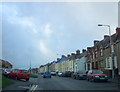
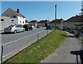
Milford Road, Haverfordwest
The road to, and from, The Haven, which lies south-west of the town. It is lined with older terraces as well as more modern housing, small businesses and some larger stores.
Image: © Natasha Ceridwen de Chroustchoff
Taken: 28 Dec 2006
0.03 miles
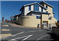
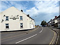
4
The Stonemason's Arms in Haverfordwest
Pub at 69 Merlin's Hill.
Image: © Jaggery
Taken: 18 Apr 2014
0.05 miles
5
Augustine Way, Haverfordwest
The houses on the south side are set below road level. Viewed from the Merlin's Hill end.
Image: © Jaggery
Taken: 18 Apr 2014
0.05 miles
6
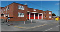
Haverfordwest Fire Station
Located on Merlin's Hill, Haverfordwest Fire Station is the Pembrokeshire Command Headquarters of the Mid and West Wales Fire and Rescue Service. The station covers the town of Haverfordwest and a large surrounding area including Johnston, Newgale, Letterston, and the A40 as far as Canaston Bridge.
Image: © Jaggery
Taken: 18 Apr 2014
0.07 miles
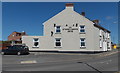
7
Tafarn Stonemason's Arms Public House
Tafarn y Stonemason's Arms yn Hwlffordd.
The Stonemason's Arms in Haverfordwest
Image: © Alan Richards
Taken: 7 Sep 2016
0.08 miles
8
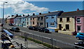
Colourful houses, Milford Road, Haverfordwest
The road is the A487.
Image: © Jaggery
Taken: 18 Apr 2014
0.08 miles
9
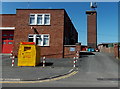
Fire station tower, Haverfordwest
Set back 50 metres from Merlin's Hill, in the NE corner of the fire station. http://www.geograph.org.uk/photo/3941162
The yellow bin is for donations to the Fire Fighters Charity.
Image: © Jaggery
Taken: 18 Apr 2014
0.08 miles
10
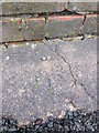
Ordnance Survey Rivet
This OS rivet can be found on the concrete base of the Ambulance Station on Mellin's Hill. It marks a point 55.248m above mean sea level.
Image: © Adrian Dust
Taken: 22 Aug 2015
0.08 miles