IMAGES TAKEN NEAR TO
Dew Street, HAVERFORDWEST, SA61 1NR
Introduction
This page details the photographs taken nearby to Dew Street, SA61 1NR by members of the Geograph project.
The Geograph project started in 2005 with the aim of publishing, organising and preserving representative images for every square kilometre of Great Britain, Ireland and the Isle of Man.

There are currently over 7.5m images from over14,400 individuals and you can help contribute to the project by visiting https://www.geograph.org.uk
Image Map
Images are licensed for reuse under creativecommons.org/licenses/by-sa/2.0
Notes
- Clicking on the map will re-center to the selected point.
- The higher the marker number, the further away the image location is from the centre of the postcode.
Image Listing (484 Images Found)
Images are licensed for reuse under creativecommons.org/licenses/by-sa/2.0
Image
Details
Distance
1
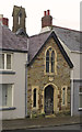
Haverfordwest - Dew Street
Colourfully painted houses in the old town of Haverfordwest, Pembrokeshire's county town.
www.haverfordwest.org
Image: © Colin Smith
Taken: 8 Oct 2021
0.00 miles
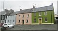
2
House at the edge of the former Pig Bank in Haverfordwest
The blue plaque http://www.geograph.org.uk/photo/4037026 on the wall gives details about the Pig Bank.
Image: © Jaggery
Taken: 18 Apr 2014
0.01 miles
3
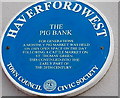
The Pig Bank blue plaque, Haverfordwest
On the wall here. http://www.geograph.org.uk/photo/4037022
Image: © Jaggery
Taken: 18 Apr 2014
0.01 miles
4
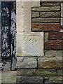
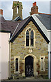
Bench Mark: Dew Street Old Infant School
At 39.65 m OD.
Image: © Dylan Moore
Taken: 30 Dec 2016
0.02 miles
5
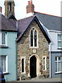
Infant school, Dew Street
This tiny school, wedged between terraced houses, is dated 1887.
Image: © Natasha Ceridwen de Chroustchoff
Taken: 27 Jan 2007
0.02 miles
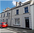
6
Former Dew Street Infants School, Haverfordwest
Dating from 1887, the building on the left was in use as a school into the 1960s, perhaps later.
Later used as a Scout Hall. Usage at the April 2014 date of this view is unknown to this contributor.
Image: © Jaggery
Taken: 18 Apr 2014
0.02 miles
7
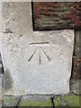
Ordnance Survey Cut Mark
This OS cut mark can be found on the old Infant School building, No43 Dew Street. It marks a point 39.650m above mean sea level.
Image: © Adrian Dust
Taken: 22 Aug 2015
0.02 miles
8
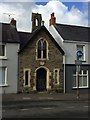
Infant School 1887
Sandwiched between houses in Dew Street, Haverfordwest - a tiny, ecclesiastical-looking Infant School.
Image: © Alan Hughes
Taken: 1 Feb 2018
0.02 miles
9
Dew Street Infants School, Haverfordwest
Established 1887: now a Grade II listed building.
Image: © Dylan Moore
Taken: 8 Feb 2013
0.02 miles