IMAGES TAKEN NEAR TO
Pembroke Road, HAVERFORDWEST, SA61 1JW
Introduction
This page details the photographs taken nearby to Pembroke Road, SA61 1JW by members of the Geograph project.
The Geograph project started in 2005 with the aim of publishing, organising and preserving representative images for every square kilometre of Great Britain, Ireland and the Isle of Man.

There are currently over 7.5m images from over14,400 individuals and you can help contribute to the project by visiting https://www.geograph.org.uk
Image Map
Images are licensed for reuse under creativecommons.org/licenses/by-sa/2.0
Notes
- Clicking on the map will re-center to the selected point.
- The higher the marker number, the further away the image location is from the centre of the postcode.
Image Listing (25 Images Found)
Images are licensed for reuse under creativecommons.org/licenses/by-sa/2.0
Image
Details
Distance
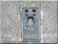
2
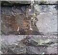
Ordnance Survey Cut Mark
This OS cut mark can be found on the east buttress of the railway bridge. It marks a point 17.310m above mean sea level.
Image: © Adrian Dust
Taken: 28 Sep 2019
0.05 miles
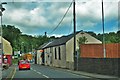
4
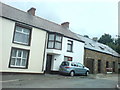
Pembroke Road, Merlin's Bridge
Outside the cheese factory.(A church is on the end of the terrace - name unknown to me).
Image: © Deborah Tilley
Taken: 17 Aug 2008
0.07 miles
5
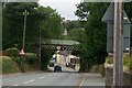
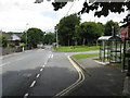
Railway bridge on the approach to Haverfordwest from Merlin's Bridge
Image: © Jennifer Luther Thomas
Taken: 11 Aug 2006
0.08 miles
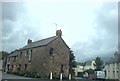
6
Wesleyan Chapel At Merlin's Bridge
Merlins Bridge Chapel was built in 1825 and renovated in 1925. The chapel is built in the Vernacular style with a gable-entry plan
Image: © Deborah Tilley
Taken: 27 Jun 2015
0.09 miles
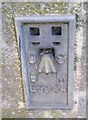
7
Ordnance Survey Flush Bracket G5044
This can be found on the buttress of the railway bridge.
For more detail see : http://www.bench-marks.org.uk/bm193
Image: © Peter Wood
Taken: 19 May 2013
0.10 miles
8
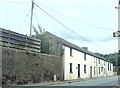
Magdalene Street, Merlin's Bridge
The name 'Merlin's Bridge' derived from the name Magdalene (pronounced Maudlin) not from the eponymous wizard!
Image: © Deborah Tilley
Taken: 17 Aug 2008
0.10 miles
9
Ordnance Survey Flush Bracket (G5044)
This OS Flush Bracket can be found on the south face of the railway bridge. It marks a point 19.472m above mean sea level.
Image: © Adrian Dust
Taken: 16 Apr 2017
0.10 miles
10
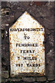
Old Milestone by Pembroke Road, Merlins Bridge, Haverfordwest
Haverfordwest plate by Pembroke Road, South of the A4076 roundabout, in parish of Merlin's Bridge (Pembrokeshire District), Merlins Bridge, 20m South of Merlins Bridge Post Office, Pembroke Road, inset into wall, East side of road.
Inscription reads:-
HAVERFORDWEST
TO
PEMBROKE
FERRY
7 MILES
237 YARDS
Grade II listed by Cadw.
Reference Number: 82634 https://cadwpublic-api.azurewebsites.net/reports/listedbuilding/FullReport?lang=&id=82634
Surveyed
Milestone Society National ID: PEM_HWPF00
Image: © Milestone Society
Taken: Unknown
0.11 miles