IMAGES TAKEN NEAR TO
Haven Road, HAVERFORDWEST, SA61 1DQ
Introduction
This page details the photographs taken nearby to Haven Road, SA61 1DQ by members of the Geograph project.
The Geograph project started in 2005 with the aim of publishing, organising and preserving representative images for every square kilometre of Great Britain, Ireland and the Isle of Man.

There are currently over 7.5m images from over14,400 individuals and you can help contribute to the project by visiting https://www.geograph.org.uk
Image Map
Images are licensed for reuse under creativecommons.org/licenses/by-sa/2.0
Notes
- Clicking on the map will re-center to the selected point.
- The higher the marker number, the further away the image location is from the centre of the postcode.
Image Listing (5 Images Found)
Images are licensed for reuse under creativecommons.org/licenses/by-sa/2.0
Image
Details
Distance
1
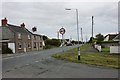
Haven Road, Haverfordwest
Looking east towards the town centre from the junction with Park Corner Road.
Image: © Simon Mortimer
Taken: 23 Aug 2012
0.07 miles
2
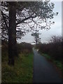
Racecourse walk
Along the western boundary.
Image: © Deborah Tilley
Taken: 14 Nov 2008
0.12 miles
3
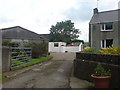
Farmyard at East Cuckoo
Once sold I expect there will be yet more farm holiday lets in the area. Witness the demise of the working farm.
Image: © Deborah Tilley
Taken: 11 Jul 2008
0.20 miles
4
East Cuckoo
On the lane to Cuckoo Grove
Image: © Deborah Tilley
Taken: 11 Jul 2008
0.20 miles
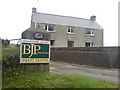
5
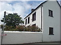
Dairy Hall
On the junction of Cuckoo Lane and Haven Road. One of the oldest buildings in the area. Once surrounded by fields.
Image: © Deborah Tilley
Taken: 11 Jul 2008
0.21 miles