IMAGES TAKEN NEAR TO
Stepney Mews, SWANSEA, SA5 8BL
Introduction
This page details the photographs taken nearby to Stepney Mews, SA5 8BL by members of the Geograph project.
The Geograph project started in 2005 with the aim of publishing, organising and preserving representative images for every square kilometre of Great Britain, Ireland and the Isle of Man.

There are currently over 7.5m images from over14,400 individuals and you can help contribute to the project by visiting https://www.geograph.org.uk
Image Map
Images are licensed for reuse under creativecommons.org/licenses/by-sa/2.0
Notes
- Clicking on the map will re-center to the selected point.
- The higher the marker number, the further away the image location is from the centre of the postcode.
Image Listing (28 Images Found)
Images are licensed for reuse under creativecommons.org/licenses/by-sa/2.0
Image
Details
Distance
1
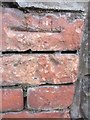
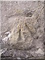
Ordnance Survey Cut Mark
This damaged OS cut mark can be found on the school wall to the north of Middle Road. It marks a point 74.557m above mean sea level.
Image: © Adrian Dust
Taken: 6 Jan 2014
0.03 miles
2
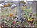
Babell Graveyard Cwmbwrla Hughes brothers
Trumpeter Edward Llewellyn Hughes of the 2nd 1st Welsh Howitzer Battery, Royal Field Artillery, who died 24th December 1916.
Corporal Brinley Clement Hughes of the Royal Field Artillery who died 30th October 1918.
https://babell-chapel.com/graves-1
Image: © Jo Mullett
Taken: 7 Nov 2019
0.06 miles
3
Stepney Street, Cwmbwrla, Swansea
Viewed from the edge of St Luke the Evangelist church http://www.geograph.org.uk/photo/3670928 looking towards the former Cwmbwrla Primary School. Burlais Primary School, which opened in September 2012, was created following the closure and amalgamation of Cwmbwrla Primary School and Manselton Primary School.
Image: © Jaggery
Taken: 25 Sep 2013
0.08 miles
4
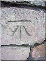
Ordnance Survey Cut Mark
This OS cut mark can be found on the school wall to the north side of Middle Road. It marks a point 64.331m above mean sea level.
Image: © Adrian Dust
Taken: 6 Jan 2014
0.09 miles
5
Ordnance Survey Cut Mark
This damaged OS cut mark can be found on No171 Middle Road. It marks a point 77.721m above mean sea level.
Image: © Adrian Dust
Taken: 6 Jan 2014
0.10 miles
6
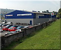
JT's Motorcycles Swansea
Viewed from Carmarthen Road. Located in Unit 1, Heol Y Gors in the Cwmbwrla district of Swansea, the business specialises in Yamaha and Suzuki.
Image: © Jaggery
Taken: 25 Sep 2013
0.11 miles
7
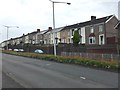
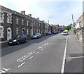
Terraced Houses
Terraced houses at Cwmbwrla on the A483.
Image: © Alan Hughes
Taken: 14 Aug 2017
0.12 miles
8
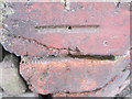
Ordnance Survey Cut Mark
This OS cut mark can be found on the wall of No376 Carmarthen Road. It marks a point 51.862m above mean sea level.
Image: © Adrian Dust
Taken: 6 Jan 2014
0.13 miles
9
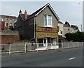
Kayvic shop in Swansea
This is the Carmarthen Road shop of Kayvic Plasterwork, a plastering firm based in Ammanford.
Image: © Jaggery
Taken: 25 Sep 2013
0.14 miles
10
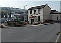
The Gate House, Swansea
This is the Middle Road side of the pub at 360 Carmarthen Road.
Image: © Jaggery
Taken: 25 Sep 2013
0.14 miles