IMAGES TAKEN NEAR TO
Aldwyn Road, SWANSEA, SA5 5BU
Introduction
This page details the photographs taken nearby to Aldwyn Road, SA5 5BU by members of the Geograph project.
The Geograph project started in 2005 with the aim of publishing, organising and preserving representative images for every square kilometre of Great Britain, Ireland and the Isle of Man.

There are currently over 7.5m images from over14,400 individuals and you can help contribute to the project by visiting https://www.geograph.org.uk
Image Map
Images are licensed for reuse under creativecommons.org/licenses/by-sa/2.0
Notes
- Clicking on the map will re-center to the selected point.
- The higher the marker number, the further away the image location is from the centre of the postcode.
Image Listing (26 Images Found)
Images are licensed for reuse under creativecommons.org/licenses/by-sa/2.0
Image
Details
Distance
2
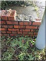
Benchmark. Cut mark, North junction of Cockett Road and Saint Peters Terrace
Cut mark can be found at the junction of Cockett Road and Saint Peters Terrace on a red bricked wall surrounding steps.
Image: © John Jenkins
Taken: 21 Feb 2023
0.06 miles
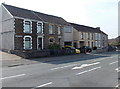
3
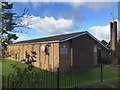
Church of Jesus Christ of Latter-Day Saints
Church of Jesus Christ of Latter Day Saints, Cockett Road, Swansea.
Image: © Alan Hughes
Taken: 5 Nov 2017
0.06 miles
4
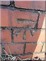
Ordnance Survey Cut Mark
This OS cut mark can be found at the junction of St Peter's Terrace & Cockett Road. It marks a point 100.023m above mean sea level.
Image: © Adrian Dust
Taken: 12 Mar 2014
0.06 miles
5
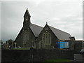
St Peter's Church
The Ordnance Survey used the Belfry as a 3rd Order Intersected Station (SN80/INT019).
Image: © Adrian Dust
Taken: 7 Apr 2011
0.09 miles
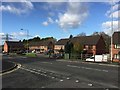
6
Eastern end of Cwmbach Road, Swansea
Viewed across the B4295 Cwmbach Road from the corner of the A4216 Station Road in Fforestfach.
Image: © Jaggery
Taken: 25 Sep 2013
0.12 miles
7
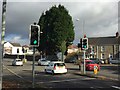
Road junction
A4216 Cockett Road junction with Cwmbach Road B4295.
Image: © Alan Hughes
Taken: 5 Nov 2017
0.13 miles
8
Clos Aneira
Housing development alongside Cwmbach Road.
Image: © Alan Hughes
Taken: 5 Nov 2017
0.14 miles
9
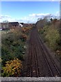
Railway line
View of railway from bridge on Cockett Road.
Image: © Alan Hughes
Taken: 5 Nov 2017
0.14 miles
10
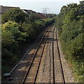
West Wales Line from Station Road Fforestfach, Swansea
Viewed from a road bridge, http://www.geograph.org.uk/photo/3672103 looking along the West Wales Line towards Gowerton station, about 4km ahead. Cockett Tunnel http://www.geograph.org.uk/photo/3672099 is about 200 metres behind the camera.
Image: © Jaggery
Taken: 25 Sep 2013
0.14 miles