IMAGES TAKEN NEAR TO
Gilfach, SWANSEA, SA4 9DF
Introduction
This page details the photographs taken nearby to Gilfach, SA4 9DF by members of the Geograph project.
The Geograph project started in 2005 with the aim of publishing, organising and preserving representative images for every square kilometre of Great Britain, Ireland and the Isle of Man.

There are currently over 7.5m images from over14,400 individuals and you can help contribute to the project by visiting https://www.geograph.org.uk
Image Map
Images are licensed for reuse under creativecommons.org/licenses/by-sa/2.0
Notes
- Clicking on the map will re-center to the selected point.
- The higher the marker number, the further away the image location is from the centre of the postcode.
Image Listing (5 Images Found)
Images are licensed for reuse under creativecommons.org/licenses/by-sa/2.0
Image
Details
Distance
2
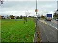
Penllergaer Common 2
Looking east from the western end showing the play area.
The proximity to traffic on the A4240 must present a big worry for the village's inhabitants.
Image: © Jonathan Billinger
Taken: 15 Oct 2008
0.15 miles
3
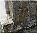
Ordnance Survey Cut Mark
This OS cut mark can be found on No37 Gorseinon Road. It marks a point 84.192m above mean sea level.
Image: © Adrian Dust
Taken: 7 Jul 2021
0.15 miles
4
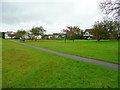
Penllergaer Common 1
Looking west from the A48 towards housing at Coedwig-Hywel.
Image: © Jonathan Billinger
Taken: 15 Oct 2008
0.21 miles
5
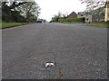
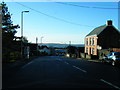
Old Llangafelach Road
A strangely wide residential road until you realise that this was originally part of the A48 trunk road to South Wales - the 3 lane structure of the road is still barely visible as are a few surviving catseyes.
Image: © Hywel Williams
Taken: 24 Apr 2009
0.21 miles