IMAGES TAKEN NEAR TO
Pontarddulais, SWANSEA, SA4 8QN
Introduction
This page details the photographs taken nearby to SA4 8QN by members of the Geograph project.
The Geograph project started in 2005 with the aim of publishing, organising and preserving representative images for every square kilometre of Great Britain, Ireland and the Isle of Man.

There are currently over 7.5m images from over14,400 individuals and you can help contribute to the project by visiting https://www.geograph.org.uk
Image Map (Loading...)


Getting Data...Please wait
Leaflet Map data © OpenStreetMap
Images are licensed for reuse under creativecommons.org/licenses/by-sa/2.0
Notes
- Clicking on the map will re-center to the selected point.
- The higher the marker number, the further away the image location is from the centre of the postcode.
Image Listing (6 Images Found)
Images are licensed for reuse under creativecommons.org/licenses/by-sa/2.0
Image
Details
Distance
1
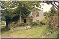
Heol Dwr
Adfail anhedd-dy o'r enw Heol Dwr a enwyd felly ar ol y ffordd a â heibio iddo. Bu Hewl Dwr, fel y'i hynganer yn lleol, yn gartref i Catherine Jones a'i merch, Eunice. Bu Catherine yn canu'r piano yng Nghapel Ebeneser, Pentrebach gerllaw. Yn drist iawn bu farw Eunice mewn ysbyty ar ol cyfnod o afiechyd ond yn drychinebol bu'r fam farw yn fuan wedyn mewn tan dinisitriol pan losgwyd y ty yn ulw yn 1964. Claddwyd y ddwy yng Nghapel y Gopa, Pontarddulais ond nid oes ganddynt garreg bedd. Yn y blaendir ar y dde gellir gweld y ffynnon.
This ruined house, known as Heol Dwr (trans. water road), is named after the unsurfaced track which runs past the property. Hewl Dwr, as it is pronounced locally, was the former home to Catherine Jones and her daughter, Eunice. The former played the piano at nearby Ebeneser Chapel, Pentrebach. Sadly, Eunice died in hospital after being struck down by an illness and Catherine, tragically, perished in a fire which destroyed the house in 1964. Both were interred at Gopa Methodist Chapel but sadly there is no memorial stone. The well can be seen in the foreground on the right.
Image: © Alan Richards
Taken: 28 Jun 1989
0.08 miles
2
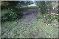
Farm Gate
There's a little green lane that links the unclassified road leading up to Graig Fawr with the Garnswllt Road. Coming down from the Graig Fawr road, at this location the track appears to continue round to the left but it's a red herring. From here the track is a private drive and the right of way dives off down to the right into trees to emerge next to Capel Ebenezer in Pentrebach.
Image: © Mama Herb
Taken: 20 Oct 2012
0.09 miles
3
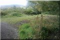
Footpath to Ebenezer Chapel
From here the right of way drops down into the trees and follows a tiny stream criss-crossing from one bank to the other across wooden footbridges.
Image: © Mama Herb
Taken: 20 Oct 2012
0.11 miles
4
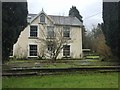
Bleak house
The grey afternoon light of early winter adds to the bleakness of this house. The footpath marked on OS maps and which appears to pass through this property is not easy to find.
Image: © Alan Hughes
Taken: 17 Dec 2018
0.21 miles
5

Autumn colours
The green foliage of the trees forms a striking contrast with the fallen leaves.
Image: © Alan Hughes
Taken: 17 Dec 2018
0.22 miles
6
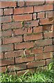
Ordnance Survey Cut Mark
This OS cut mark can be found on a building at Glynfid Farm. It marks a point 97.432m above mean sea level.
Image: © Adrian Dust
Taken: 24 Feb 2014
0.23 miles