IMAGES TAKEN NEAR TO
Pentre Road, SWANSEA, SA4 8DD
Introduction
This page details the photographs taken nearby to Pentre Road, SA4 8DD by members of the Geograph project.
The Geograph project started in 2005 with the aim of publishing, organising and preserving representative images for every square kilometre of Great Britain, Ireland and the Isle of Man.

There are currently over 7.5m images from over14,400 individuals and you can help contribute to the project by visiting https://www.geograph.org.uk
Image Map
Images are licensed for reuse under creativecommons.org/licenses/by-sa/2.0
Notes
- Clicking on the map will re-center to the selected point.
- The higher the marker number, the further away the image location is from the centre of the postcode.
Image Listing (5 Images Found)
Images are licensed for reuse under creativecommons.org/licenses/by-sa/2.0
Image
Details
Distance
1
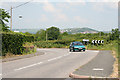
Grovesend Community: nearing Waungron
Looking north on the Gowerton – Pontarddulais road
Image: © Martin Bodman
Taken: 8 Jun 2006
0.02 miles
2
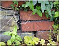
Ordnance Survey Cut Mark
This OS cut mark can be found on the brick gatepost of No204 Pentre Road. It marks a point 23.604m above mean sea level.
Image: © Adrian Dust
Taken: 7 Jul 2021
0.03 miles
3
Llwybr Maes yr Ellyn Path
Llwybr sy'n cysylltu Heol Alltygraban â threflan Waungron. Â'r llwybr heibio yn agos i anhedd-dy Maes yr Ellyn.
A public footpath linking Alltygraban Road (trans. Corn marigold) with the hamlet of Waun Gron (trans. round meadow). The path passes close to a property known as Maes yr Ellyn.
Image: © Alan Richards
Taken: 11 Feb 2014
0.15 miles
4
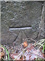
Ordnance Survey Cut Mark
This OS cut mark can be found on the north parapet of the railway bridge on Allt-y-Graban Road. It marks a point 30.989m above mean sea level.
Image: © Adrian Dust
Taken: 13 Dec 2015
0.22 miles
5
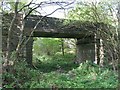
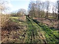
Allt-y-Graban road crosses dismantled railway
Modern maps plot the route of the Gower Way as coming up this railway line and taking Allt-y-Graban Road east to Pontlliw. I think though that the intention is to approach on the common a little to the west rather than down in the actual railway.
Image: © Nigel Davies
Taken: 10 May 2009
0.22 miles